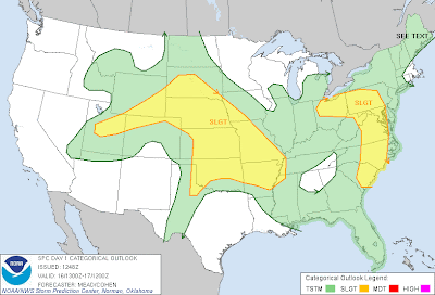
Severe thunderstorms are possible across a broad area from the central & northern Plains into portions of the intermountain region, as well as another area from the Ohio Valley into the Carolinas this afternoon & evening (as indicated by the yellow shaded areas on the image above).
Large hail and damaging winds will be the greatest severe weather threats today, however isolated tornadoes also cannot be ruled out, particularly when storms initially form and are more isolated and well organized.
Two clusters of thunderstorms continue to move Southeast this morning, having originally formed from overnight thunderstorm activity to the Northwest. One is currently located over Kansas and the other is located over northwest Arkansas. The Arkansas cluster is diminishing rather rapidly at this time, but the cluster over eastern Kansas is holding some organization. It is possible that additional re-development / re-organization of thunderstorm activity will take place along and ahead of these clusters later this afternoon. If this were to occur, it would most likely take place over western / southern Missouri, southeast Kansas and adjacent portions of northeast Oklahoma or northwest Arkansas. Other re-development may also take place over central or southeast Arkansas along any outflow boundaries left behind by that cluster of storms.
It will become more clear by midday or early afternoon what, if any, boundaries are left behind by this activity, and what may focus additional thunderstorm development along or ahead of them this afternoon. We'll post an additional update as that becomes more certain.
Otherwise, thunderstorms are expected to re-form by mid to late afternoon across portions of the High Plains (from Nebraska and South Dakota,
Southward into Western portions of Kansas and Oklahoma) and move Eastward. This activity is likely to congeal into one or more thunderstorm complexes later this evening and tonight, continuing to the East or Southeast (much like what took place during the pre-dawn hours of this morning).
Other development is expected to take place this afternoon & evening across the risk area in the Eastern U.S., with large hail & damaging winds being the primary threats.


No comments:
Post a Comment