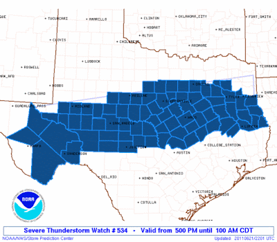
Clusters of thunderstorms are currently forming over east-central and northwest Texas. Further development is expected in between these two clusters, as well as over southwest Texas this evening. While some of the activity may be accompanied by hail and high winds, the main story here is that much, much needed rain will fall over many areas. A Severe Thunderstorm Watch is in effect for a large swath of Texas, from Southwest to East/Northeast, until 1am CDT Wednesday morning:
The storms that are developing now are expected to congeal into one or more complexes and traverse toward the East/Southeast across the state this evening & into tonight. The HRRR Computer Forecast Model currently predicts a cluster of strong to severe storms will impact the San Antonio-Austin corridor along I-35 toward Midnight:
While the prospects of severe weather may not be all that appealing, we are in a "beggars can't be choosers" situation for sure, so we'll gladly take whatever we have to get along with the much needed rain. I, for one, hope that the above model verifies 100%.
I'll be monitoring trends this evening and will make another post later on as it becomes more clear what the late evening & overnight situation looks like, both with respect to rain & potential severe weather for the Austin/San Antonio region.
In the meantime, if you are lucky enough to find yourself in the path of a storm in Texas this evening, remain alert and seek shelter if threatening weather approaches, but otherwise, just sit back and enjoy the rain!


No comments:
Post a Comment