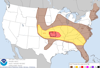
Above is the midday severe weather outlook from the SPC in Norman, OK. The overall severe weather risk area (yellow shaded area on image) has not really changed from the early morning version, however some revisions were made to the areal coverage of the highest damaging wind and hail risk, as shown on the images below.
The regions with the highest risk of damaging thunderstorm winds are within the red shaded areas on the image below. "Significant" wind damage is possible within the black hatched area, which includes the Wichita, Springfield and Joplin areas:
Very large hail is also likely with severe storms that form in the red shaded areas on the image below, with "significant" (i.e., tennis ball size or larger) hail possible within the black hatched area:
A complex of thunderstorms continues to advance into the the Deep South at this time. Severe Thunderstorm Watches are currently in effect for these areas, with damaging winds and hail the primary threats this afternoon:
Back over the Central Plains, a boundary from overnight thunderstorm activity generally extends West to East just to the North of the Missouri/Arkansas border, and on into southeast Kansas. This boundary is expected to focus thunderstorm development by late afternoon or early evening across this region.
Large hail & damaging winds will be the primary severe weather threats, however isolated tornadoes are also possible during the initial stages of development. By mid to late evening, it appears that a significant threat of damaging winds will develop across the red shaded and black hatched area on image #2, from southeast Kansas into much of central & southern Missouri.
This activity is expected to congeal into one or more thunderstorm complexes overnight, and track East/Southeast into adjacent portions of the Mississippi and Tennessee Valley areas. Damaging winds and very heavy rainfall will be the primary threat by this time.
The potential exists for widespread power outages in any area that is impacted by significant damaging winds this evening and/or tonight. If you live in this portion of the outlook area (the red shaded and black hatched areas on image #2), please take the time today to stock up on batteries and make sure that you have a battery powered NOAA Weather Radio available should an extensive power outage strike your area during severe weather. This could also be your best bet to make sure that you receive a severe weather warning for your area if you live further East where the activity may not move in until later in the overnight hours.
NOAA Weather Radios are available at most major retailers, including RadioShack, which in my opinion has the widest variety in stock at any given time. You can also stock up on batteries and flashlights there as well.
Whatever the source, please be sure to pay attention to the weather this afternoon & evening if you live in these areas, and listen for later statements, watches and warnings...


No comments:
Post a Comment