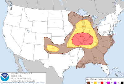
Above is the latest severe weather outlook for today from the SPC in Norman, OK. Severe thunderstorms are possible within the yellow shaded areas on the image. Within the overall severe weather threat area depicted above, there is an elevated risk of damaging winds and large hail, generally within the red shaded areas on the image below:
A complex of strong to severe thunderstorms, which originated yesterday evening over Iowa & northern Missouri, is currently moving Southeast across southeast Missouri and southern Illinois. The complex has weakened slightly over the past 1-2 hours, however locally strong, gusty winds will continue to be a threat along and ahead of this complex this morning.
This complex will leave behind several surface boundaries that will focus severe thunderstorm redevelopment later this afternoon across portions of the mid-Mississippi and Tennessee Valley areas. Large hail, damaging winds and isolated tornadoes will be possible with this activity.
Otherwise, several clusters of severe thunderstorms are forecast to develop this afternoon & evening across portions of the Midwest, Great Lakes and into the western Ohio Valley. Large hail & damaging winds will be the greatest threat with this activity, although isolated tornadoes also cannot be ruled out, particularly with any storm that is able to remain rather isolated and become well organized.
Just like yesterday, activity that forms this afternoon & evening is likely to congeal into one or more thunderstorm complexes that will roll to the East/Southeast overnight tonight. Damaging winds would be the primary threat by that time.
A smaller area of severe thunderstorm development (geographically speaking) is forecast to take place over portions of southeast Colorado, northeast New Mexico and into the Texas/Oklahoma panhandle region this afternoon & evening. Large hail and damaging winds will be the primary hazards in this area, although isolated tornado development is also possible.
If you live in or near any of the above areas, please remain alert this afternoon & evening and be prepared to seek shelter if threatening weather approaches your area. Take the time now to review severe weather preparedness tips, and have a plan in place to take action on short notice if necessary.


No comments:
Post a Comment