As expected yesterday, the severe thunderstorm activity that developed over Kansas & Missouri yesterday evening congealed into a large complex of storms overnight, and has raced Eastward into portions of Kentucky and Tennessee as of this writing:
This system produced a swath of wind damage reports from southern Missouri and Illinois into Kentucky overnight and early this morning. Damaging winds will continue to be a threat along and ahead of this complex this morning and midday. Very heavy rain and dangerous lightning can also be expected as this system continues to move and/or develop toward the East/Southeast.
Meanwhile, conditions are coming together for another round of severe thunderstorm development later today, into this evening & tonight. Below is the latest severe weather outlook from the SPC in Norman, OK:
Severe thunderstorms are possible anywhere within the yellow shaded areas on the above image. In particular, a more concentrated threat of severe thunderstorms (including tornadoes) is forecast within the red shaded area on the same image, across portions of northwest & northcentral Kansas into the southern half of Nebraska.
Thunderstorms are forecast to develop first along the front range and foothills of the Rockies by mid to late afternoon. Some of these storms are likely to become severe and will move Eastward into the adjacent High Plains over time. Large hail, damaging winds and isolated tornadoes will be possible with this activity.
Thunderstorms are also expected to develop along and either side of a warm front extending along or near the Kansas / Nebraska border by early evening. Very large hail, damaging winds and tornadoes will all be possible with this activity as it moves and/or develops Eastward during the evening hours.
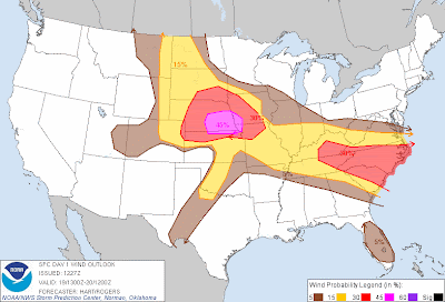
The threat for tornadoes will be highest late this afternoon & evening within the red shaded area on the image above. The threat for damaging winds will be highest within the red and pink shaded areas on the image below:
Large hail will be a distinct possibility with severe storms that form late this afternoon & evening, with the highest threat being within the red shaded areas on the image below. Very large hail (i.e., 2 inches in diameter or greater) will also be possible with this activity, primarily within the pink and black hatched areas on the same image:
The thunderstorm activity that forms over Nebraska and Kansas this afternoon & evening is likely to again congeal into one or more large complexes of thunderstorms overnight tonight, which will move downstream into portions of the Midwest and Tennessee Valley. Damaging winds will be the primary threat once the activity transitions into this mode overnight.
Elsewhere, isolated to scattered severe storms are possible very late this afternoon into this evening along the dryline from southcentral Kansas into portions of western & central Oklahoma and extreme northwest Texas. A very strong capping inversion will exist in this region, so activity is not expected to be widespread. Any storm that does form, however, is likely to quickly become severe. Very large hail, damaging winds and isolated tornadoes will be possible with this activity.
If you live in any of the severe weather outlook areas for today, please stay alert and be prepared to seek shelter if threatening weather approaches your area.


No comments:
Post a Comment