As expected, yesterday was a very active severe weather day, with widespread reports of large hail, damaging winds and a concentrated area of tornadoes in Nebraska, northwest Kansas and parts of Iowa. In total, just over 350 reports have been received thus far, and we'll likely hear of more today as damage is surveyed from activity late yesterday evening & overnight.
See postings here and here for a video and photo of one of the largest Nebraska tornadoes. More photos and videos will be posted later today as they start flowing in.
I am happy to say that, so far, there have been no reports of deaths or serious injuries associated with yesterday's tornadoes and/or damaging winds. I'd like to think that's a testament to the warning process and folks being aware and staying alert in the severe weather threat areas. Hopefully we'll see that again today, (although the threat is not as pronounced as it was yesterday).
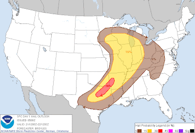
Above is the latest severe weather outlook for today from the SPC in Norman, OK. Severe thunderstorms are forecast within the yellow shaded areas on the above image. Large hail & damaging winds will be the primary severe weather threats today, however isolated tornadoes also cannot be ruled out, particularly when storms are within their first few hours of development.
An enhanced threat for damaging winds is forecast within the red shaded areas on the image below:
...and an enhanced threat of very large hail (golfball size or greater) is forecast within the red areas on the image below:
A cluster of strong to severe storms continues over northeast Texas and northern Louisiana this morning, with another less intense cluster moving East through the St. Louis area:
Marginal hail and/or wind gusts to severe limits may occur for a few more hours with this activity, and the clusters will also leave behind surface boundaries that could focus redevelopment of thunderstorm activity later this afternoon.
Otherwise, thunderstorms are expected to redevelop by mid to late afternoon along and ahead of a cool front and dryline from the Midwest into the central and southern Plains (near the Western edges of the severe weather outlook area from the 2nd image). Outflow boundaries from the morning thunderstorm complexes may also focus redevelopment near and/or East-Southeast of where they diminish later this afternoon.
Large hail and damaging winds will be the primary severe threats today, however isolated tornadoes are also possible with any more isolated storms that are able to organize prior to merging into a larger complex or cluster of activity.
At this time, it appears that storms within the red shaded areas on the 3rd and 4th images are likely to become the most organized today, with locally enchanced potential for damaging winds, large hail & isolated tornadoes. This would include portions of far eastern Iowa, southern Wisconsin, much of central & northern Illinois and extreme east-central & northeastern Missouri. Another band of locally enhanced severe potential appears to be setting up across southwest Arkansas, southeast Oklahoma and northeast Texas.
If you live across or near any of the severe weather outlook areas for today, please remain alert and be prepared to seek shelter if threatening weather approaches your area.


No comments:
Post a Comment