Mark Vogan's Video-Blog for Sun, 4 Jul, 2010 CHECK OUT FACEBOOK
Today's Top Weather Stories
On Weather & Climate Through the Eyes of Mark Vogan
Watching the Tropical Atlantic, Gulf and Caribbean this Week
AccuWeather News
A once every 10-year event will impact the I-95 this week
100-degree heat from Washington DC to New York
If Philadelphia and Central Park, New York reach 100, this would be the first time since August, 2001.
By Mark Vogan

The European Model for Monday, Jul 5.
Why has this not occured since then? Not only do you require a strong high pressure cell overhead but the core of high pressure must be just east, southeast of Washington and Philadelphia, alignment of southwest winds which drive the intensely hot air into the Northeast must fire straight out of the southwest and right into the I-95 corridor. The 850mb level temperature must be very warm or unusually warm to support the surface temperatures required. You really want that 850mb level or 5,000ft above the ground, temperature to be 24C or higher, then project that temperature down to the surface and your talking temperatures of around 95-97 degrees F, given little cloudcover and winds are SW. That is what forecast models are projecting from Monday through Thursday from DC to New York. You ask, how is it meant to reach 100 all the way to NYC then?

The European model for Tuesday, Jul 6.
Well, another two key factors must be added into the mix, 1) dry soils which has been the case throughout the Mid-Atlantic and southern New England recently and the dry air mass that controlled this region over the past 4-5 days allowed further drying out of the soils... 2) the southwest wind which drives hotter air in, re-inforcing the 95-97-degree air already in place. This SW wind can downslope the east face of the Appalachain mountains FURTHER heating the air as it downslopes, compresses and therefore heats the already hot air, pushing this added heat into the big cities.
Washington DC tends to experience 100s perhaps ever other summer, when high pressure is strong over Virginia or the Southeast, Counterclockwise winds blow down the Appalachains and there, DC hits 100, like we've already seen twice in 2010 already. It is much more difficult to support 100s to New York City as mountains are further west, and the air does tend to cool slightly by the time it reaches Manhattan. However like we saw in 2001 and we may likely see this upcoming week. Instead of 2 out of 3 ingredients in place around New York, ALL ingredients are there for 100s to make it all the way to Central Park. Philadelphia, though like New York doesn't have as high a chance of reaching the century mark compared with Washington which is further south and closer to the mountains for downslope enhancement. However, in saying that Philly does have a slightly better chance than NY at 100, therefore in my opinion, DC and Baltimore has a 100% chance, Philadelphia a 98% chance, Newark a 95% chance and New York's Central Park a 90% chance at seeing a high at or above 100 this week.
In fact DC has a 98% chance of reaching 100 on at least 3 days, 95% chance that Philadelphia reaches it on at least 2 days and 88% chance that Newark reaches it on at least 2 days. Central Park's greenery and foliage as well as shelter from surrounding sky scrapers makes Central Park tough to get real heat to that site, the greenery and foliage tends to make things a few degrees cooler than say La Guardia Airport to the east in Queens where there is concrete in abundance. Newark also tends to run 3-6 degrees higher than Central park to the southwest because of the added concrete as well as a further west and inland locale.
Most summers recently have been wetter than normal, the higher soil moisture has held summer maximums lower than we saw during the drought years of the late 1990s, 2001 and 2002 but there are more similarities to the drier early 2000s than wetter mid to late 2000s across the Northeast. August 2006 was the last time it came close to reaching at each site from DC to New York. LaGuardia not only warmed to 102 degrees on a few afternoons that month but it also saw it's warmest ever night with a low of 87 degrees. Philly topped 99 degrees with nighttime 80s, DC topped 102 and over 100 on several days. but Central Park being bias cool because of it's surroundings fell short of it's warm neighbours of Newark and LaGuardia with a high of only 97 degrees whilst both sites of Newark, NJ and LaGuardia Apt in Queens reached 100.
My predicted highest temperatures and warmest night lows this week.
Washington DC Hi 104 degrees, Lo 82
Baltimore Hi 104, Lo 82
Philadelphia Hi 102, Lo 83
Newark Hi 104, Lo 84
New York (Central Park) Hi 100, Lo 79
LaGuardia Apt Hi 103, Lo 86 (only 1 degree shy of warmest night on record in Aug 2006)
your america today forecast
by mark vogan
northeast & mid-atlantic
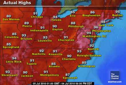
Hope you enjoyed your "cool" days of late with low humidity and almost chilly nights because the heat is ready to build northeastwards today. Yesterday was like the frying pan and over the next 5 days will will be nothing short of "fire" as the hottest weather in 8 years swelters a region from Virginia to New York City. Highs today should hit 95 from DC to New York and all points in between, with the odd 96-97 in some spots, including Newark, New Jersey. I expect Boston to warm to around 90 degrees by late this afternoon. What you'll find is that humidity over the next few days rises with the heat and although tonight should be warm with lows only falling to around 75 or slightly higher for most places, by Tuesday Wednesday and Thursday, you might find lows struggle to get below 85 degrees! Yes that's not a typo. Highs from Mon-Thurs should take a run at 100.
southeast
The Southeast will enjoy lower storm chances today and especially down along the Gulf Coast where it's been a rough few days from Houston to New Orleans and all the way across and down through Florida. Skies clear out somewhat from New Orleans to Atlanta where temps will warm up as the high builds back in again with we should see highs near 90 this afternoon, under mostly sunny skies at New Orleans with similar conditions up in Atlanta. Lows tonight as usual drop to the low to mid-70s for Atlanta and the interior Southeast as well as inland Florida to upper 70s nearer the Gulf Coast and coastal areas of Florida. Thunderstorms are expected more out to Texas and as usual throughout Florida where heat induced sea breezes start to converge from noon onwards. Highs throughout Florida should be uniformly in the mid to upper 80s throughout the state today.
southwest
A cooler regime is in place across the deserts with highs only slightly topping 100 degrees for both Las Vegas and Phoenix and only upper 70s for Salt Lake and Denver as the NW trough lowers pressures but raises them further east. Along the West Coast, nothing changes, lows in the 50s and 60s with fog and cloud developing and pushing inland to the mountains, during the day the reverse during the late morning with PM sunshine and highs in the 60s and 70s at the coast with your typical onshore flow, 80s for the coastal valleys and canyons, 90s for the Inland Empire and low 100s for the high and low deserts. Death Valley may be the hot spot in the nation with a high near 110. Lows tonight will drop to the 70s for most desert communities including the big cities. Around 60 for Downtown LA and San Francisco.
northwest
Another cool day for the PNW but the heat is set to build for Seattle, Portland and inland areas over the next few days and likely we'll see the warmest of the year along the coastal plains and urban corridor. Lows tonight drop into the mid-50s for most areas, 40s in the higher elevations.
northern plains
The tropical conveyor belt continues to roll from the western Gulf to Canada with persistent tropical downpours, soupy dew points and high in the 80s from Minot to Minneapolis southwards to Chicago. Lows range from the 50s over the western Dakotas to 60s and 70s further east into the central and eastern plains where that very mugger air is flowing northwards from the tropics. So, showers and indeed thunderstorms are in your forecast if you live in the eastern Dakotas through Minnesota, Iowa and northern Missouri. central Plains from Kansas City to St Louis will see a chance for storms and downpours and highs that push the low 90s!
southern plains
Texas will once again endure a risk of showers and thunderstorms, though perhaps not just as high across such as large area as we have seen of late, but Alex's remnants linger on throughout the Southern Plains and with the potential for development with a low off Louisiana, this risk of heavy showers may be worsened throughout Texas within the next 36 to 38 hrs. Highs should be uniformly in the upper 80s across Texas and Oklahoma. Lows in the 70s.
Today's Weather across America
From AccuWeather

Dangerous Eastern Heat Wave Could be a Record-Breaker
AccuWeather
A "Swell" Independence Day on Southern California Beaches
AccuWeather
Violent Storms to Stymie Festivities, Travel in Minneapolis, Chicago, Denver
AccuWeather
Flooding Downpours Target the Southern Plains
AccuWeather

Weather Talk
By Mark Vogan
Wet and Windy for Scotland, 79 for southeast England. 101 degrees Breaks a Record at JFK Airport, New York this afternoon!
A wet and very windy afternoon and evening here across Scotland after another warm day across the southeast of England. That warm trend continues and there's no end to the warmth in sight, certainly highs look to continue pushing at least the upper 70s from London to East Angelia as the high persists. Here in Scotland, we have a low off to the northwest, pushing pressures down and bringing a persistent supply of unsettled weather to the northern half of Britain and it appears as though that will continue this week.
As for the building heat wave over the Eastern third of the US, we saw a hot start to this very long, steamy week ahead and certainly when you see these highs from DC to Boston and the air mass set to get even warmer, there is little doubt we will see the first 100 for Philadelphia and Central Park, NY for the first time in nearly 9 years.
JFK AIRPORT, NEW YORK 101 (RECORD)
NEWARK, NEW JERSEY 101
CENTRAL PARK, NY 96
PHILADELPHIA 96
FLUSHING, NY 97
THE HAMPTONS, LONG IS 96
WASHINGTON DC 94
BOSTON, MA 95
STAY TUNED...
What's Reaching Today's Blogs?
Lightning Strikes Thrice in Chicago
Jesse Ferrell, AccuWeather
Today's US Extremes
Courtesy of AccuWeather (as of 3pm)
High: 115 degrees at Death Valley, CA
Low: 28 degrees at West Yellowstone, MT
Today's UK Extremes
Courtesy of the Met Office
High: 79 degrees at Norwich Airport
Low: 43 degrees at Exeter Airport
Today's Extremes here at my house
High: 62 degrees
Low: 56 degrees
TODAY'S COND
Heavy rain and strong winds from the south
Thanks for reading.
-Mark


No comments:
Post a Comment