Background: All right whales, north and south, were taxed hard and early by human whalers—the "right" whales to hunt because their high blubber content made them likely to float after death and because they frequented near-shore waters.
That made them easy to get to even in the days of rowing.
(A painting, artist unknown, showing the hunting of right whales. La Baleine. The Whale, circa 1840. Credit: Wikimedia Commons.)
Some 150,000 Southern Hemisphere right whales (Eubalaena australis) were killed by 19th-century whalers and by illegal 20th-century Soviet whalers—driving the species to the brink of extinction.
Around Australia and New Zealand, hunting peaked in the 1830s-1840s, after which the species was commercially extinct.
(Geographic range of the southern right whale. Via the Red List.)
The latest IUCN estimate of southern right whales dates back to 1997 when they calculated a population of 7,500 individuals.
At that time, several breeding populations (in Argentina/Brazil, South Africa, and Australia) showed evidence of strong recovery, with a doubling time of 10-12 years.
Which means there might be a fair few more than 7,500 whales today.
According to the authors of the MEPS paper, no right whales were seen in the waters around mainland New Zealand for 35 years between 1928 and 1963. A few slowly returned. Yet as recently as 2005 less than 12 sexually mature females were found there.
But another group, known as the New Zealand subantarctic group, has a more robust population estimated at about 936 whales today. Forebears of this group were likely present in some small numbers even in the bleakest killing years.
The authors of the MEPS paperwondered about the levels of relatedness between those two whale stocks in New Zealand, as well as among whales in Australia.
They used mitochondrial DNA and microsatellite genotypes to identify 707 individual whales and test them for genetic differentiation. You can see the breakdown of that analysis in the graphic above.
Their data, combined with historical evidence, led the researchers to hypothesize that individuals from the NZ subantarctic are slowly recolonizing mainland New Zealand waters, where a calving ground was obliterated in the 19th century.
The genetic evidence also suggests that the whales of southeast Australian are a remnant stock—different from the whales of southwest Australia:
At the onset of whaling, southern right whales, in particular cows with calves, were found across the southern coast of Australia during the austral winter (IWC 1986). There was no real discontinuity in distribution or catch records to suggest subdivision of calving grounds in this region (IWC 1986). Based on the timing of catches at shore whaling stations during the 19th century, Dawbin (1986) proposed that southern right whales undertook 2 distinct patterns of migration along the southern coast of Australia during the austral winter. The southern right whales that migrated north along the east coast of Tasmania [the small island off the southeast tip of Australia, as seen in the graphic above] moved in a northeasterly direction up the coast of Victoria and New South Wales, while those that migrated north along the west coast of Tasmania moved from east to west along the southern coast of South and Western Australia. The latter pattern is still extant, based on the movement of photo-identified southern right whales and has been termed the 'counter-clockwise' migratory pattern (Kemper et al. 1997, Burnell 2001).
They also found evidence that New Zealand and Australian right whales mingle in higher-latitude summer feeding grounds each austral spring—making the health of those cold Southern Ocean waters as important a component of recovery as the whales' breeding efforts.
And what epic efforts they are. Imagine a 12-foot-long penis—known colloquially as a sea snake—plus a tons' worth of testes per male. Mating becomes a sport of endurance. And sperm competition.
But you don't have to imagine it. As usual, just for us, David Attenborough respects the privacy of none.
Carroll, E., Patenaude, N., Alexander, A., Steel, D., Harcourt, R., Childerhouse, S., Smith, S., Bannister, J., Constantine, R., & Baker, C. (2011). Population structure and individual movement of southern right whales around New Zealand and Australia Marine Ecology Progress Series DOI: 10.3354/meps09145
#BRITISH ISLES-EUROPE Mighty thunderstorms fuelled by strong cold front sweeps France and low countries reducing temperatures dramatically, introducing refreshing airmass, fine rest of the week for UK
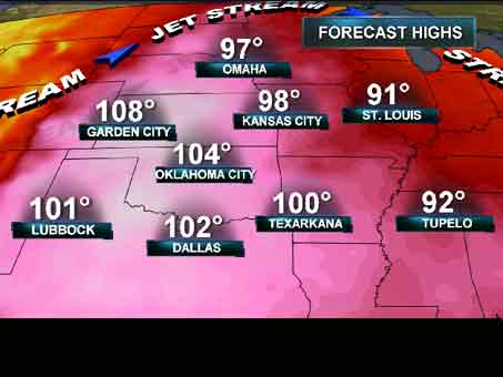
#USA Killer Heat Bakes US Central Plains today
#WEATHER TALK 2011: The year of global disasters? But is this the only time our planet has undergone turbulent timesof this magnitude and frequency both below and above the surface?
#BRITISH ISLES-EUROPE Mighty thunderstorms fuelled by strong cold front sweeps France and low countries reducing temperatures dramatically, introducing refreshing airmass, fine rest of the week for UK
#USA Killer Heat Bakes US Central Plains today
#WEATHER TALK 2011: The year of global disasters? But is this the only time our planet has undergone turbulent timesof this magnitude and frequency both below and above the surface?
At 7am CDT, the center of Tropical Storm Arlene was located along the Mexican coast near Cabo Rojo. Maximum sustained winds were estimated at 65 mph, and the minimum central pressure was 29.32 inches of mercury.
Arlene is moving West at 8 mph, and will continue on this general motion as she progresses into Mexico today and tonight. Very heavy rains and strong, gusty winds can be expected well inland across Mexico through Friday:
Bands of rain and thunderstorms, some heavy, continue to stream along the Northern edge of Arlene into the Brownsville, McAllen and adjacent portions of Deep South Texas this morning:
This trend will continue today, with up to 2 inches of rain possible in heavier showers. The heaviest rains, which will exceed 6 inches in some areas, will take place South of the border into Mexico:
At 5pm CDT...a Hurricane Hunter aircraft measured sustained near-surface winds of 60 mph in association with Tropical Storm Arlene. The center of the system was located about 120 miles East of Tuxpan, Mexico, and moving West at 7 mph. Minimum central pressure was measured at 29.41 inches of mercury.
The Government of Mexico has issued a Hurricane Warning from Barra De Nautla to La Cruz. This replaces the Tropical Storm Warning and Hurricane Watch that was previously in effect.
The latest radar image from the Alvarado, Mexico radar is below, and gives us a nice look at the southern-most precipitation bands associated with Arlene:
During the afternoon, bands of thunderstorms and showers have clipped the extreme southern tip of Texas, near the Brownsville area, in association with the northern-most extent of Arlene. According to the latest Brownsville radar image (below), additional showers and thunderstorms will continue to brush far South Texas later this evening & into tonight as Arlene begins to make landfall well to the South in Mexico:
The official National Hurricane Center forecast (below) continues to keep Arlene below Hurricane force through landfall, but there is still a chance that the system could arrive along the central Mexican coast as a minimal hurricane on Thursday morning.
For regular news and updates, see the blog on Facebook and click 'like'
In Today's Blog
#BRITISH ISLES-EUROPE Mighty thunderstorms fuelled by strong cold front sweeps France and low countries reducing temperatures dramatically, introducing refreshing airmass, fine rest of the week for UK (includes dramatic videos of the storms from Youtube)
#USA S. Plains heat expands north with 100s possible as far north as North Dakota
#WEATHER TALK 2011: The year of global disasters? But is this the only time our planet has undergone turbulent times of this magnitude and frequency both below and above the surface?
At 10am CDT, the center of Tropical Storm Arlene was located about 155 miles East/Southeast of Tampico, Mexico, and moving West at about 8 mph. Maxiumum sustained winds are estimated at 50 mph, and the minimum central pressure was 29.53 inches of mercury.
Some additional strengthening is forecast as Arlene continues on a general Westward path over the next 24 hours. The following forecast track from the NHC still shows Arlene remaining at Tropical Storm force through landfall, however she may reach minimal hurricane force prior to making landfall:
The government of Mexico has issued a Hurricane Watch from Tuxpan to La Cruz. A Tropical Storm Warning remains in effect from Barra De Nautla to Bahia Algodones.
Very heavy rain, strong, gusty wind and dangerous surf can be expected along the central Mexican coast through tomororw.
klepto: Greekκλέπτης("thief") and κλέπτω("steal") + parasitos: παράσιτος("person who eats at the table of another")
Meaning: The parasitic theft of captured prey, nest material, etc., from animals of the same or another species; such as the theft by a gull* of a featherwight GoPro camera from a tourist on the French Riviera.
Tropical Storm Arlene has formed in the extreme southern Gulf of Mexico. At 7pm CDT, the center of Arlene was located 280 miles East/Southeast of Tampico, Mexico, and was moving West/Northwest at 7 mph. Maximum sustained winds were estimated at 40 mph.
The official NHC forecast track is shown below. At this time, Arlene is not expected to reach hurricane strength before making landfall along the Mexican coast on Thursday afternoon:
An Air Force Hurricane Hunter aircraft investigated the area of disturbed weather (dubbed "Invest 95") in the Bay of Campeche this afternoon. While they did find a closed circulation (an area of low pressure), they did not find a core of sustained winds strong enough to classify the system as a Depression. This is likely due to the fact that middle & upper level winds are still causing some shear over the system, preventing it from fully organizing. That condition, however, is expected to change over the next 12 hours, which will allow the system to undergo some fairly rapid organization.
Below is the latest image from the nearby Alvarado, Mexico radar:
You can see some of the outer feeder bands of precipitation beginning to flow Westward into the radar's view. The center of the system is off to the right (or East) of the image.
The system continues to maintain a slow West/Northwestward drift, and this motion is expected to continue for the next few days. Below is the latest computer model forecast track of the system over the next 3-5 days, which continues this same general motion:
It is quite likely that the system will become at least a depression during the next 12-24 hours. If surface winds become sustained at 39 mph or higher, we could jump right into Tropical Storm Arlene - which would be the first named storm of the 2011 Atlantic Season.
Regardless of the eventual classification of the system, very heavy rains and gusty winds will continue to be produced across portions of Central America and the Mexican coast (particularly the Mexican states of Tamaulipas and Veracruz) over the next few days.
For regular news and updates, see the blog on Facebook and click 'like'
In Today's Blog
#BRITISH ISLES & EUROPE Cold front sweeps off Kent coast tonight, allowing overnight cooling throughout South of England. Stormy cold front supports powerful thunderstorms and large temperature drop over France, all the hot, humid air is pushed into Germany and eastern Europe!
#USA Scorching heat pulsates from Texas to Arizona back to Texas...
In a post yesterday evening, I commented on a tropical disturbance that had flared up over parts of Central America & southeast Mexico.
As of midday today the system continues to slowly try to get organized (as noted by the white circled area on the above satellite image). It continues to drift very slowly toward the West/Northwest.
The National Hurricane Center (NHC) plans to send a "Hurricane Hunter" aircraft into this system later this afternoon to investigate and see if the system has developed any organized circulation or low pressure center.
Computer forecast models continue to develop the system over the next few days, and keep it on a general West/Northwestward track:
We'll provide more updated information later today as data flows in from the NHC aircraft.
A complex of severe thunderstorms continues to advance South/Southeastward across portions of the Mississippi Valley and the Deep South at midday. Damaging winds and large hail are likely with both of the bowing segments that you can see on the above radar image.
Severe Thunderstorm Watches have been issued along and South of this activity into the afternoon hours. The latest watch includes a part of far northeast Texas, and it is certainly possible that the band over Arkansas will continue to develop back Westward far enough to impact part of northeast Texas later this afternoon.
For additional details on the remainder of the severe weather threat for this afternoon & evening, please see my earlier post.
Above is the latest severe weather outlook for today from the SPC in Norman, OK. Severe thunderstorms are possible anywhere within the yellow shaded areas on the above image.
Severe Thunderstorm Watches are currently in effect across portions of the Deep South, as a complex of severe thunderstorms with damaging winds continues to move Southeastward this morning:
An enhanced risk of damaging winds will continue along and ahead of this activity today, as indicated by the red shaded areas on the image below:
Additional clusters of severe storms are expected to form this afternoon & evening across portions of the mid-Atlantic and Deep South. Several boundaries being produced by the current complex moving across Arkansas, Mississippi and Alabama will also focus additional development during the heat of the day, particularly to the South of the location of the current thunderstorm complex. Damaging winds & large hail will be the primary severe weather threat across this region today, although an isolated tornado cannot be ruled out. This would particularly be the case with any thunderstorm that is able to remain rather isolated and become well organized.
Further West, scattered severe storms are forecast by mid to late afternoon across portions of east-central & northeast Colorado. Large hail and damaging wind gusts are the primary threat with this activity, however isolated tornadoes are also possible during the first few hours of initiation. This activity is likely to congeal into one or more clusters or a small complex and move East/Southeast into adjacent portions of western Kansas this evening, and perhaps as far as the Oklahoma panhandle or northwest Oklahoma region tonight. Damaging winds would be the primary threat by that time.
The above satellite image was taken just a moment ago. The red circled region on the image denotes a tropical disturbance over the Eastern part of the Bay of Campeche. This system is currently dubbed "Invest 95L". (For more information on the various stages of tropical system classification, see a recent post here). It is drifting very slowly toward the West/ Northwest - a motion that is expected to continue for the next few days.
A "Hurricane Hunter" aircraft is scheduled to visit this disturbance tomorrow if it continues to slowly organize overnight. Right now, middle & upper-level conditions are not favorable for rapid development, however that will change over the next few days, with more favorable conditions for development possible by Wednesday.
Very heavy rains and gusty winds will continue across portions of southeastern Mexico and much of Central America for the next few days as this system drifts slowly West/Northwestward.
Computer forecast models are currently keeping the system on a general West/ Northwestward track for the next 5-7 days, as shown on the latest composite computer model forecast image below:
Keep in mind that errors in the computer models can be quite large beyond the 2-3 day timeframe with this type of developing/infancy stage system, so take the above image "for what it's worth..."


