
As expected, on the midday update, the SPC extended the enhanced risk of severe weather southward from portions of central & eastern Kansas to central Oklahoma for this afternoon & evening (as indicated by the red shaded area on the image above).
Strong to severe thunderstorms are already forming on the High Plains, and a Tornado Watch with enhanced wording ("This is a particularly dangerous situation with the threat of damaging tornadoes...") was just issued for portions of Nebraska and northwest/northcentral Kansas, valid until 8pm CDT:

Thunderstorms are expected to develop & quickly intensify across the watch area this afternoon and track further toward the East/Northeast by evening. Very large hail, damaging winds and strong tornadoes are possible in this region. This threat of significant severe weather will shift Eastward into adjacent portions of eastern Nebraska and western through central Iowa later this evening. Additional watches will be required for this region later this afternoon and/or evening.
Further Southward, thunderstorms are expected to form along the dryline in central & eastern Kansas by mid to late afternoon, and spread Eastward into the evening. Very large hail, a threat of significant damaging winds, and a few tornadoes are possible in this region. The greatest tornado threat in this region would likely occur prior to sunset, with the primary threat being significant damaging winds thereafter.
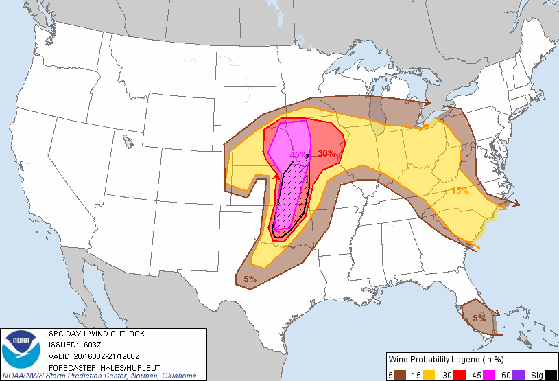
Significant wind damage possible in black hatched areas.
Isolated to scattered thunderstorms are also expected to form across central Oklahoma and part of extreme northwest Texas, along the dryline. This activity is likely to develop by late afternoon into early evening. While very large hail & significant damaging winds are the highest threats in this region, an isolated tornado or two cannot be ruled out, particularly during the first few hours of development. This activity will move East/Northeast and could affect portions of Northeast and/or East-Central Oklahoma later this evening.
If you live in any of the areas specified in the paragraphs above, please continue to pay very close attention to the weather this afternoon & evening. Be prepared to seek shelter if threatening weather approaches your area.
If you live further to the East of the above mentioned areas (i.e., eastern Iowa, Missouri, and adjacent regions), be aware that one or more organized complexes of thunderstorms are likely to traverse Eastward during the overnight hours. Stay tuned for later information as this threat becomes more clear. Damaging winds would likely be the greatest threat in these areas overnight.


No comments:
Post a Comment