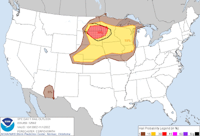
Above is the latest severe weather outlook for today from the SPC in Norman, OK. Severe thunderstorms are forecast within the yellow shaded area on the above image.
Severe thunderstorms are forecast to develop by early to mid-afternoon from portions of southern North Dakota into South Dakota and Nebraska. Large to very large hail, damaging winds and isolated tornadoes will be possible with this activity. The tornado threat will be greatest during the first few hours of initiation, as storms remain more widely spaced and have better potential to organize.
The threat of very large hail, damaging winds and tornadoes will be greatest in and near the red and black hatched areas on the image below:
Thunderstorms will move and develop East/Southeastward over time, and may form into one or more clusters or complexes of storms that continue Eastward overnight tonight. By that time, damaging wind gusts would be the primary severe weather threat.
If you live in or near the above mentioned areas, please remain alert for possible severe weather this afternoon and evening. Review severe weather preparedness tips and be prepared to seek shelter if threatening weather is observed or a warning issued.
If you enjoy reading 'The Original Weather Blog', please be sure to "like" our facebook page!


No comments:
Post a Comment