TODAY'S TOP WEATHER STORIES
On Weather & Climate Through the Eyes of Mark Vogan
AMERICAN MIDWEST
ANOTHER MAJOR SNOWSTORM, ANOTHER HISTORY MAKER!

Minneapolis, Minnesota
Image Courtesy of Kare 11 News
Messy commute in metro after winter storm
KARE 11
Minneapolis declares record 8th Snow Emergency
KARE 11
Minn. Digs Out From Record Feb. Snowstorm
WCCO-TV

Image Courtesy of the Star Tribune
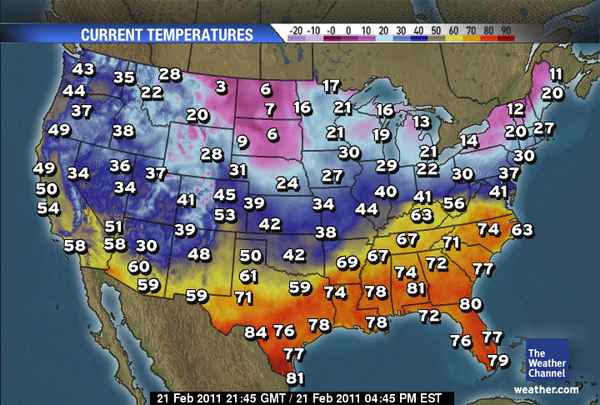
A Very Cold Start Across Northern Rockies & Plains As Storm Progresses East
Don't be fooled by last week's 30s, 40s and 50s across the Northern tier, as you'll have already seen, winter is back with a vengence across the Northern Plains reminding residents that are digging out as well as shivering this morning that there's plenty more winter left in this season yet, afterall, it's still only February and I'm betting March has plenty of tough winter weather ahead for the winter-weary American North!

Southeast Enjoying Spring-Like Warmth Whilst It's Back to Winter Across Northeast
After a tough few weeks in particular in a region not farmiliar with severe cold and snow, well it may well be near the end for this winter, however whilst I believe an early start to spring is on the cards from New Mexico to Georgia and perhaps up into the Carolinas, winter may hold strong for another several weeks across the North and with a La Nina pattern in control now and the pattern showing that, we may find a stormy, though warm spring across the South whilst we may not have seen the last of the snow and bitter cold for a while yet for the North.
LATEST WEATHER ACROSS AUSTRALIA

Australia Cyclone Springs Back to Life
ACCUWEATHER NEWS
BBC
ACCUWEATHER NEWS
TODAY'S WEATHER ACROSS THE UK & EUROPE
Milder weather ahead
BBC
Today's BBC UK Forecast
Today's BBC Europe Forecast
TODAY'S WEATHER ACROSS AMERICA
From AccuWeather

Quick Hitting Storm Jabs the Midwest
By Katie Storbeck, Meteorologist
Major Severe Weather Threat May Begin Thursday
By Alex Sosnowski, Expert Senior Meteorologist
Late Week Storm Could Be Big Trouble
By Alex Sosnowski, Expert Senior Meteorologist
Second Snowstorm To Get Pittsburgh, Philadelphia, DC
By Alex Sosnowski, Expert Senior Meteorologist
WEATHER TALK
By Mark Vogan
FRIGID AIR CONTINUES TO DOMINATE SCANDINAVIA, THE BALTICS, WESTERN RUSSIA AND THE UKRAINE

Moscow Shivering In “Coldest Winter In 100 Years”
Helsinki, Tallinn, Riga and Moscow as well as across a much broader area have all seen nearly a week of nights dipping under -20C with such cities as Tallinn, Estonia and Helsinki, Finland dropping below -25C at night under perfect conditions of clear skies, liught winds and abundant, deep snowcover, not forgetting the far northerly latitude. This air is becoming more extreme as we approach late February because though this is a typically cold region of the world in winter and even at this late stage in winter (winter can last into April in this region), but certainly these numbers are more common for cold waves during the period from late December through early February, however though nights are brutally cold, days are showing the late stage of the season.
The past couple of days has seen a slight moderation in the cold across Moscow, however, it's still well below normal with lows dipping to a current -18C whilst further north and west, the thermometer in both Tallinn and Helsinki are falling through the -20sC now and perhaps on their way towards -30C by morning. Days are (I believe) showing that it's late winter simply because for the depth of the cold we're seeing at night here, with an early return of sunlight and that sun climbing higher in the sky by day, temperatures aren't as cold as they could be, given those numbers witnessed at night. It's rising to around -12C or even slightly warmer, though it's well below seasonal averages, given the -25 to -30C readings at night, had these temperatures been registered a month ago then it's likely we'd have been seeing highs in the -18C or lower range because of lower, weaker sunlight, longer duration of darkness etc, especially this far north which is in line with northern Hudson Bay in Canada which is frozen over half the year!
VAGARIES OF THE WEATHER
INDIA & SUB-CONTINENTAL ASIA WEATHER
BY RAJESH KAPADIA

Sunday Extreme Vagaries in Delhi and Mumbai:
Sunday, 20th. Feb in Delhi and Mumbai.
F3 effect on Delhi:
Rainfall: 15 mms.
Central India UAC-1 effect in Mumbai:
Wind Gusts Reaching 44 kmph in the afternoon.
Both Photo Courtesy "The Hindustan Times ".
UAC-1 in Central India is moving eastwards, rather getting pulled eastwards. This will make the advent of F4 into Northern India easier and faster.
F4 will precipitate in N.Pakistan and India from Wednesday thru Friday. Much of Kashmir, H.P., Utteranchal and NW India plains will be under medium precipitation Wednesday thru Friday, 25th Feb.
Another Upper Air system (UAC-2) is possible in Central Mah. and adjoining South M.P ,as a secondary to F4 from Wednesday. . May precipitate rains in Vidarbha and adjoining A.P.
This Week Summary Forecast: (Subject to minor variations)
Tuesday, 22nd. : Medium rain in interior Karnataka and parts of T.N.
Wednesday, 23rd. : F4 effect Northern Pakistan. Into India, it rains/snow in Kashmir while light rains continue in interior Karnataka .
Thursday, 24th. : F4 effective in Kashmir, H.P. and light precipitation in Punjab and Haryana. Secondary UAC-2 could form and precipitate medium rains in Vidarbha, South M.P. and interior Karnataka.
Friday, 25th.: F4 anchored in hills now, and spreading into Western Nepal. Central India UAC-2 could weaken and gradual decrease in rains in East Mah. and adjoining regions from Friday.
Tuesday ICC World Cup Cricket match may be free of rains in Nagpur, but Friday's cricket may be interrupted by rains.
Thursday's ICC Cricket World Cup match in Delhi can be interrupted by light to medium rain.
CLICK HERE FOR THE BEST INDIA AND SUB-CONTINENTAL WEATHER INFORMATION. I AM PROUD TO BE A PARTNER!
WHAT'S REACHING TODAY'S BLOGS?
Very Cold and Snow in the Northwest, Drops South Late Week
Ken Clark, West Expert, AccuWeather
Back to Where We've Been
Joe Lundburg, AccuWeather
Winds Send Bounce House Flying in Arizona
Jesse Ferrell, AccuWeather
THE EXTREMES OF THE DAY
TODAY'S US EXTREMES
COURTESY OF ACCUWEATHER
HIGH: 94 degrees at McAllen, TX
LOW: -22 degrees at Willow City, ND
TODAY'S EXTREMES HERE AT MY HOUSE
HIGH: 38 degrees
LOW: 36 degrees
Thanks for reading.
-Mark


No comments:
Post a Comment