TODAY'S TOP WEATHER STORIES
On Weather & Climate Through the Eyes of Mark Vogan
BLIZZARD BLASTS ACROSS AMERICAN NORTH AFTER A WEEK OF MILD WEATHER
It's been a season packed with Major Storms, Lots of Cold and Plenty to Talk About

Image Courtesy of Star Tribune
By Mark Vogan
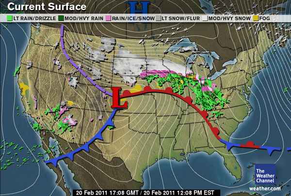
It's been quite the winter hasn't it. For the Midwest with December's huge Snowstorm which hammered Minneapolis, February's 20 inch blizzard that hit Chicago and all the cold that went with it, or the huge blizzard that crossed the Southern Plains the brutal, frigid air which drove in behind the two storm's rewritting weather history in that region, let's not forgot the Northeast Coast's snowstorms also!...
EVERYONE IS READY FOR SPRING and unfortunately those dying to see spring across the Northern Plains and Midwest once again will be at the mercy of old man winter's fury as a major snowstorm rolls west to east across the Dakotas, Minnesota and into Wisconsin. The cold is back across the Northern Rockies and even in that part of the world, Glasgow, Montana has seen the most snow in a season since records back with over 80 inches. Along with the massive snows here, it's been cold with temperatures can under 40 below zero around Glasgow, colder in other areas of the state and along with that, windchills have gotten well into the 50 below territory. AMAZING!
Mark Vogan Explains The Difference Between Early/Mid-Winter Storms and Late-Winter/Spring Storms

FUELLING ELEMENTS TO THIS LATE SEASON STORM:
1) LARGE TEMPERATURE CONTRAST

2) INCREASE IN GULF HEAT AND MOISTURE A MAJOR FACTOR
Along with the moist/humid and spring-like air flowing northwards into the Heartland storm system, there is more and more influence of heat as we're now into late February and at this point in the winter season, warmer air can get further north than say a month ago, dew points are beginning to increase as the sub-tropical high which is displaced way south into the Caribbean Sea and deep tropics during the December-January and early February period intensifies as the sun grows stronger and gets higher in the sky. As this high which dominates the US during summer grows stronger and heads north it pushes heat up into the Southern States as the jet stream has commenced it's northward retreat. However this warmer air only get's so far and only to be fought back by late season cold that still dominates the American North and Canada. As fight time begins as the 'stormy' spring season approaches and strong west to east moving Pacific storms roll across the continent, atmospheric fuel levels increase at this stage in winter as the warmth and higher dew points can finally get back onto the American weather map rather than being forced into the tropics. Often the strongest winter storms occur in late February and or March, bringing with them higher snow totals, often stronger winds, more severe weather outbreaks across the South because of this return of warmer, juicier air. Of course there is still bitter cold over the Northern tier and Canada, so, infuse these two air masses together over the Plains and East and bang, you got powerful storms which often herald a wild closure to another winter season in the USA. Out ahead of these storms which usually get cranking once east of the Rockies as there is a greater depth of atmosphere to play with as well as the northward surge of the vital warmth and heat to drive these systems across the Plains and towards the Eastern Seaboard. Often areas to the east of the storm will get record warmth before getting slammed, then 6-12 hours later, their is bitter cold, afterall it's still February and we can and are seeing with this storm that there's a heck of a lot of severely cold air over Western Canada!


Blizzard Hammering The Dakotas, Minnesota
ACCUWEATHER NEWS
Mn DOT: 'Folks Really Shouldn't Travel
STAR TRIBUNE
February Flakes Push Metro Closer To Record Snowfall
WCCO-TV
IN OTHER NEWS TODAY
BBC WEATHER
Today's Special Feature:
TODAY'S WEATHER ACROSS CANADA
From The Weather Network

THE WEATHER NETWORK
THE WEATHER NETWORK
THE WEATHER NETWORK
THE WEATHER NETWORK

Rideau Canal, Ottawa, Ontario
(Photo Courtesy of The Weather Network)
Nina Ridge Present's Today's BBC UK Forecast
Susan Powell Present's Today's Europe Forecast
TODAY'S WEATHER ACROSS AMERICA
From AccuWeather

Storm Continues In Desert Southwest, Rockies
AccuWeather
Two Rounds Of Snow In Store For Northeast
AccuWeather
Blizzard Hammering the Dakotas, Minnesota
AccuWeather
WEATHER TALK
By Mark Vogan
Cold Looks Likely to Stay Strong Over Western Canada, Meaning Potential For Wild Last 4-5 Weeks of Winter For North America

It would appear that Arctic air will remain strong over the west of Canada for the foreseeable future and with this late time of year now and building warmth coming up from the tropics and colliding with Arctic air over the US Heartland can only mean one thing, trouble!
It fast approaching springtime and when there's a La Nina, this often means and fast and furious start to severe weather season. It's been evident over the past week at the warmth and increasing humidity is coming and coming quick, but because of the type of winter season the continent has seen, winter isn't going to go without a fight!
WHAT'S REACHING TODAY'S BLOGS?
Update: 12-15"+ By Midday Monday
Paul Douglas Weather Column (WeatherNation)
Sunday Afternoon Update in the Storm
Henry Margusity, AccuWeather
Not So Quiet This Week
Frank Strait, AccuWeather
THE EXTREMES OF THE DAY
TODAY'S US EXTREMES
COURTESY OF ACCUWEATHER
HIGH: 92 degrees at Laredo, TX
LOW: -20 degrees at Bridgeport, CA
TODAY'S EXTREMES HERE AT MY HOUSE
HIGH: 42 degrees
LOW: 37 degrees
Thanks for reading.
-Mark


No comments:
Post a Comment