TODAY'S TOP WEATHER STORIES
On Weather & Climate Through the Eyes of Mark Vogan
ATTENTION: Strong low to bring "STORMY WEATHER tonight and particularly tomorrow for Scotland, N. Ireland and northern England (see Weather Talk below for details)
Storm of A Lifetime leaves Chicago area and Midwest Crippled and Stunned, Arctic Pile Driver sends Shivers down to Texas in amazing style
A PERSONAL IN-DEPTH ANNALYSIS BY MARK VOGAN ON THE GROUNDHOG DAY STORM OF 2011 AND STUNNING COLDWAVE IT'S WAKE
HIGHLIGHTS
*CHICAGO, IL: 20 INCHES OF SNOW "OFFICIALLY" FALLS
*HOUSTON, TX HITS 21 DEGREE LOW WITH WIND CHILLS FALLING INTO SINGLE DIGITS. IT WE BE A STRUGGLE TO CLIMB ABOVE FREEZING TODAY THERE

CHICAGO, IL (tribune)
The storm which has been dubbed the "Groundhog Day Storm/Blizzard" certainly lived up to it's much anticipated hype and billing as it wound up firstly over North Texas, dumping upwards of 2-4 in Dallas, TX (locally higher), 2-12 to the west and north with Oklahoma City, OK not only breaking a "daily" snow record but it came close to tying the city's monthly snow record, all within just one day in a single day. Over 11 inches of snow fell in Oklahoma City. Quite amazing.
As this storm cranked up BIGTIME at the base of the trough centered over the spine of the country, it commenced it's northeast journey towards Chicago deepening and continuously sucking moisture up from the warm, tropical Gulf waters, it was fuelled by the shear power of the Arctic cold flowing down on it's backside and the warm, moist air that the system was ingesting on it's front side. Upper level dynamics were also extremely conducive. All these factors played that critical role in strenghening this storm into a history maker.

BACKSIDE WINDS TO THE REAR OF THE STORM MADE OKLAHOMA AND NORTH TEXAS FEEL MORE LIKE 20 TO 35 BELOW ZERO!
After the storm blew gale-force winds within and around it's center on it's northeast treck Chicagobound, winds howlled out of the north at 20-40mph on it's rear making the 2-4 degree air over Oklahoma and North Texas which had began digging out, feel like between 20 to 35 below zero. The wrap-around moisture being forced north on it's leading edge, just out and ahead of it's powerful cold front rapisly transitoned from heavy and torrential rains which were being released by front-running understorms within the warm sector transitioned to heavy, windswept snow. The copious amounts of Gulf origin moisture enetered not just a cold environment but a FRIGID one and this enhanced snowfall to much greater rates than normal (because of just how cold the air was) and thus thunder, lightening and 50 to 70-mph winds blew throughout eastern Oklahoma, Kansas, Missouri yesterday morning and early afternoon, soon ending leacing behind clearing skies but very windy conditions and windchills 10, 20, even 30 below zero in it's wake. By late afternoon the powerhouse storm system brought blizzard conditions to St Louis and Kansas City which forced the closure of 1-70, linking the two major cities and then by late afternoon and into the evening, whilst Kansas City and St Louis continued to get hammered, it was northern Illinois's turn and all eyes were on Chicago.

NOAA IMAGE (tribune)
IT WAS THE PERFECT STORM TRACK FOR CHICAGO!
Indeed, as the storm's crucial track of northeast movement, to the south of the city and all the fine ingredients continuing to maintain themselves and feeding the storm over the Ohio Valley with extremely frigid feeding into the storm's rear and warmn, moist air flow ahead of the cold front which forced storng thunderstorm to blossom over the Mississippi Valley and Ohio Valley in the warm sector, the dynamics were excellent for a "major, potentially record-breaking storm for Chicago". Winds blowing out of the northeast at 25 to 45mph sustained with gusts building throughout the evening to beyond 50mph. Lake Michigan enhanced Chicago's snowfall and this meant higher totals than what would have been, had the winds not blew off the Lake.

CHICAGO, IL (tribune)
20 INCHES DOWN, 10 FOOT DRIFTS LEFT BEHIND AS STORM DEPARTS, EASES
As of early afternoon today (local time), Chicago though still very windy has seen an end to the snowfall as the system roars off to the northeast and WEAKENS as the dynamics begin to breakdown.. Why? Well the thermal contrast that was very large over the center of the country is now lessening fast as the system enters a more uniformly cold environment and one which sees lesser and lesser amounts of available moisture.
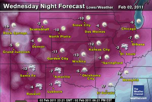
TONIGHT, AIR WILL BE BETWEEN -4 AND -10 FROM AMARILLO, TX TO CHICAGO, IL
EXTREMELY COLD NIGHT AHEAD FOR EVERYWHERE, LIKELY THE COLDEST OF WINTER FROM DALLAS, AMARILLO TO CHICAGO
It's rare to see the cold as strong as it is, as far south!
0 degree line, below Amarillo, 10 degree line near Dallas, 20 degree line around Houston (mid to upper 10s in north in surrounding burbs) and near 25 degree line down to Gulf Coast at Galveston.
It's rare to see this intensity of Arctic air as far south and it appears tonight may be the all out coldest of the season and easily the coldest in some 15 years for Texes and Oklahoma.
The perfect setup for maximum radiational cooling all the way to the shore of the Gulf of Mexico should be in play for tonight in which we see the 0-degree line drop well into north Texas with possibly 5 to 6 below zero in Dalhart and Amarillo, the 5-8 degree line down below the Dallas-Fort Worth area with possibly a record low of 8 degrees in Dallas (current record, 14) and even the 20 degree sinking below Downtown Houston with a low possibly dipping to 18 or 19 degrees and locally 14 to 16 in surrounding burbs. Galveston may flirt with 25 degrees.
Further north and it's below zero for literally all of Oklahoma and northwards with a possible record low of 5 or 6 below zero for both Oklahoma City and Tulsa and locally 8 to 12 below zero in cooler outlying areas which are situated in shallow valleys which see cold air draining.
A Widespread area stretching from northeast Oklahoma into Kansas, Missouri to Illinois may take a run at 5 to 15 below zero with Kansas City dipping to potentially 8 to 10 below zero, St Louis 2-4 below zero and Chicago may see 6 to 8 below zero tonight.
The reason for such extreme and rare cold is thanks to a huge Arctic high which moved all the way from Alberta and Saskatchewan, Canada which erased their warmth of the 40s and 50s back to the -20s, 30s and even -40s in spots (eg, Key Lake, Sask) all the way down to eastern Colorado and remains at 1050mb which contains extremely low pressure heights within and thus indicitive of bitterly cold air aloft. Factor in lighter winds than last night, clearer skies and of course a widespread snowcover and you've got the perfect environment to support record cold all the way into northern Mexico. The storm itself has forced a further south advancement of the Arctic pool and also sets a colder base for cooling tonight and that means numbers tonight, should, in theory be lower for most!
MARK VOGAN'S THOUGHTS: WHY WAS THIS STORM SO POWERFUL, BREAK THE RECORDS IT DID?
RARE COLD AND SPRING-LIKE CONVERGES OVER NORTH TEXAS
I personally think that this storm cranked up the way it did because of the power of the Arctic high which was centered to the northwest of the low, super cold air, rarely on the table when a storm is centered in the Texas Panhandle meant a rare weather map was unfolding. This feed of unusually cold air all the way down to Texas meant, rapid deepening of the storm. There was also very warm, juicy air at hand and up for grabs just south and east of the low in the Gulf, as the system deepened thanks to these "at hand" perfect, high octane fuels for storm development, the system deepend and as it did the wheels were set in motion as the "speeding up of the storm's circulation", this forced these conflicting air masses to be sucked in, as they did, we therefore see stronger thunderstorms, heavier rains and gusty winds on the warm side and stronger winds, heavier snows and greater blizzard conditions which produced thundersnow on the cold side!
GROUNDHOG DAY STORM STORIES
Massive Blizzard Wallops Chicagoland
CBS CHICAGO
Lake Shore Drive A Disaster; Drivers Stuck For Hours
CBS CHICAGO
LOOKING ON THE BROADER SCALE!
Brutal Sub Zero Cold Gripping Over A Dozen States
ACCUWEATHER NEWS
Oklahoma City: Almost A Monthly Record In One Day
ACCUWEATHER NEWS

Crippled Lake Shore Drive, Chicago (tribune)

Crippled Lake Shore Drive, Chicago (tribune)
THE COLD HARD FACTS
Texans encouraged to conserve as rolling blackouts continue *Updated*
HOUSTON CHRONICLE
Blizzard Ends, Dangerous Cold Settles In
KMBC.COM (KANSAS CITY)
More cold to come: Houston will struggle to get above freezing Wednesday
KHOU.COM (HOUSTON, TEXAS)

TODAY'S WEATHER ACROSS SCOTLAND, UK
'Stormy Weather set for North Britain tomorrow'
(See Weather Talk below for details)
This evening's BBC Scotland Forecast By Gail McGrane
WEATHER TALK
By Mark Vogan
'STORMY WEATHER ARRIVES TOMORROW ACROSS SCOTLAND, N. IRELAND AND NORTH OF ENGLAND'
TONIGHT'S WIND, RAIN, SLEET, SNOW AND HAIL WILL BE A SIGNAL OF STORMIER WEATHER WHICH WILL ADVANCE IN FROM THE ATLANTIC TOMORROW! DAMAGING GUSTS ARE HIGHLY POSSIBLE...
The weather is set to turn very active over Scotland, Northern Ireland and the north of England as tomorrow arrives, but before that whilst tonight will see a band of heavy, possibly "very heavy" rain which will transition to snow, even at low levels across the Central Belt by morning and with this and blustery winds, this will be a mere sign of things to come as tomorrow morning turns to afternoon.
Areas from Stranraer up to Ayr, Largs, and into the Greater Glasgow all the way across to the Lothians and Edinburgh will see a secondary band of heavy rain (possibly some sleet, snow and hail) following tonight, into tomorrow morning's band and accompanying this will be strenghening winds which will reach gale to even SEVERE GALE force by the afternoon tomorrow!
Check ahead for travel info and if your out and about, please do take care as the weather looks set to turn nasty. Don't be surprised if you hear thunder and see lightening!
FRIGID AIR RULES CENTRAL USA

Note the 9 degree high at Amarillo, TX and 1 at Goodland, KS!

Note the 30 below wind chill at Amarillo this morning!

Just look at those forecast lows for tonight!
VAGARIES OF THE WEATHER
INDIA & SUB-CONTINENTAL ASIA WEATHER
BY RAJESH KAPADIA
See Mumbai Page Updated –Sharp Contrast, High Temperature.
Massive Giant Storms of the U.S. and Yasi magnitude draws major attention of meteorologists, but some minor happenings are on around the Indian Sub-Continent:
Southern Region:
91B is currently situated at 5.9N and 83.4E. Wind speed just about 15 kts.and pressure at 1008mb, its just about qualifies as a well marked low. Being embedded in the E. wave, we should presume it to travel east and cross the Sri Lanka coast by tomorrow.Sri Lanka east coast can expect heavy rains due to this system, and some "spill over" on the South T.N. coast. Rainfall into T.N. will not be really heavy, just about as indicated in Vagaries forecast map.
Northern region:
Firstly I reproduce the blog of 31st. Jan ..so that a continuity is maintained and references are easier..
"Approaching W.D. will precipitate rains in Dubai from Tuesday evening thru Thursday. Cooler temperatures in Dubai on 2/3 Feb due to overcast conditions and rains.
Rain/snow spreading to Western Pakistan (Balochistan) and Central regions on Wednesday/ Thursday. Effective rainfall could be possible in Central Sindh. UTH maps indicate scattered rainshowers also possible along Sindh coast on Thursday.
W.D. will be in force in to N.India from Thursday 3rd. Feb."....
The anticipated W.D. is now over Pakistan, where precipitation should have commenced from Wednesday night in the Northern, NWFP and Balochistan areas. Overall, these regions will get good rains/snow Thursday thru Saturday, with Upper Sindh areas getting the odd thundershower on Thursday/ Friday. Sukur and Jacobabad might see these showers.
Actually, on Thursday, the W.D. low is centred over Pakistan's Punjab region, with the precipitation belt stretching from Dubai NE thru Balochistan, Punjab (Pakistan) into Northern Pakistan and North India.
Dubai has received rains today, Wednesday from this system. Strong winds raised sand and dust, and showers lashed the city between 6pm and 7 pm. A reader has put up this pic today taken from her car.
Moving into India from Thursday, states of Kashmir and H.P. will receive heavy snowfall onThursday thru Monday, and disruption likely in the 2 states due to snow accumulation.The system is expected to persisit due to trough in the upper air stabilising for a few days over the region. Rains/snow in the Northern regions of India will hang on till Monday, after which it will penetrate into Utteranchal hills, U.P. plains and western Nepal.
The plains of Punjab and Haryana will get thundershowers, with the odd one popping up in N.Rajasthan.
Nepal areas will start getting the benfits of this system from Sunday. Kathmandu should get the rainfall on Monday, 7th.( am I attempting an extra long range forecast??)
Cold conditions will re-establish over India and Pakistan from this weekend.
SEE OUR PARTNER'S BLOG HERE!
WILD WEATHER ON A WILD WORLD
MEXICO AND CONTINENTAL WEATHER
BY ARTURO SALINAS
Temperature Departures From Normal!

SEE ARTURO'S BLOG HERE!
WHAT'S REACHING TODAY'S BLOGS?
Groundhog Day Storm Greatest Hits
Jesse Ferrell, AccuWeather
Trying to Find That Corner Spring Is Behind
Joe Lundburg, AccuWeather
A Look at the Next Storm Coming Saturday
Henry Margusity, AccuWeather
THE EXTREMES OF THE DAY
TODAY'S US EXTREMES
COURTESY OF ACCUWEATHER
HIGH: 85 degrees at Ft Pierce, FL
LOW: -43 degrees at Chinook, MT
TODAY'S EXTREMES HERE AT MY HOUSE
HIGH: 48 degrees
LOW: 36 degrees
Thanks for reading.
-Mark


No comments:
Post a Comment