If you haven't already, click 'LIKE' on the WEATHER & CLIMATE THROUGH THE EYES OF MARK VOGAN blog FACEBOOK PAGE for regular 'on-the-road' updates, links to be biggest stories, photos and video thoughout the day, 7 days a week on your local, national and international weather.
TODAY'S TOP WEATHER STORIES
On Weather & Climate Through the Eyes of Mark Vogan
Asian Sub-Continent sees World's first 50C (122F) high of 2011
Turbat and Jacobabad, Pakistan both soared to the severe level of 50C or 122 degrees F, a fiery peak in what has been a gradual warming trend over the past 10 days following a cool April and early May over the region.
This first 50C high, though arriving, statistically on time, follows a relatively cool April and May. This is in stark contrast to April and May 2010 which saw 5-7C above normal and multiple days of today's 50C value over the scalding Thar Desert which spreads from south-central Pakistan into northwest India. This year has seen temperatures run 5-7C below normal.

Floodwaters to linger in Mississippi town for weeks, forecasters say
CNN
Cajuns to blame for their own flood misery? Not so fast
NBC NEWS

Tropical Storm Eyes Philippines and Japan
ACCUWEATHER.COM
TODAY'S WEATHER ACROSS UK & EUROPE By Mark Vogan
Heat induced showers and thunderstorms are popping over much of Europe, Chilly breezes and hefty showers continue to plague Scotland
The strong low remains the dominant feature driving the UK's weather. While Scotland barely reaches 11C despite some sunny spells, the westerly wind blowing in is making for a chilly feel and also ushers in some lively showers which have delivered hail. The southern half of the UK, though brighter, warmer and nowhere near as wet is also less warmer due to the presense of the low to the north and west.
ENTIRE EUROPEAN MAINLAND BENEATH DOMINANT HIGH
It's once your across the North Sea and English Channel that your more likely to see sunnier conditions and much warmer temperatures The high remains strong and dominant, holding the low to the NW of Scotland. The immediate coastlines of NW and N France up along Belgium, Holland and Denmark is where you'll see the coolest daytime temperatures and more in the way of showers. Look for highs today and tomorrow at perhaps only 18-20C with passing showers in between abundant sunshine. These showers and embedded thunderstorms will run from the Bay of Biscay northeastwards into southern Scandinvia, around the high that's over Spain and France.
These showers are created by the boundary between low pressure to the NW and high pressure to the SE. Once your away from both influences such as the cool waters of the sea and channel as well as the low to the NW, your going to see highs climb well into the 20s C (70s and 80s F). Most spots over ALL of mainland Europe, that's a huge region from south-central Spain where highs will near 30C or 86F all the way up through Germany and into Poland towards the Asia border will enjoy mostly sunny skies and highs today and tomorrow of between 24-32C (76-90F). Many areas will see pop-up showers and thunderstorms that are created by strong surface heating. If you glance at the afternoon radar over Europe, you'll see those balls of convection blow up in isolated, individual clusters across the warming mainland.
ITALY AND GREECE NOW IN THE CLEAR
After the pesky low delivered rains and cool, cloudy weather to the south-central countries of Italy Greece and surrounding nations, this low is low spread out across Turkey and into extreme west-central Asia (northern Syria, Iraq, Iran, Georgia, Azerbajan towards the Caspian Sea). This allows abundant sunshine and warmth here now.
TODAY'S WEATHER ACROSS AMERICA By Mark Vogan
Improvement for Northeast on Saturday but messy weather continues across South with further flooding over flood zones around Ohio and Mississippi Rivers

While it's you folks over the Northeast that will FINALLY get a break from your persistent rains over the past 5 days, it's the Southern Plains which get stuck in a rut of daily showers and thunderstorms, especially strong once daytime heating kicks in. The Southern Plains from south-central Texas north up into Kansas and a line towards these states eastern borders that we're seeing strong thunderstorm form along the cold front with other storms forming behind them to the west where the dry line is.

The map above from The Weather Channel shows the setup. The storm continues to draw cold upper level into the Southern Plains which is met by warm, juicy air flowing up from the above-normal Gulf of Mexico. The two contrasting air masses shoot the lapse rate through the roof (tewA5Walo0Q0GPpHJPR0MOYZ2Zr6PoCSA29 and this is what is firing off supercells west to east up and down the front. The storm and trough is the very feature that will force the ridge to it's east, towards the Northeast and this, in turn, shoves out the low that's been causing all the issues in the Northeast.
The problem is, after today and tomorrow's severe weather across Texas, Oklahoma and Kansas, like we saw yesterday, this system will progress further east. Not only will we see the severe weather risk spread up into the Ohio Valley and Lakes but an increased flow out of the south, as the front gets nearer will transport 65 to 75 degree dew point air currently floating over the Gulf waters northwards and across the Flood Zone. Unfortunately when looking ahead the next several days, further heavy rains will fall in the wrong places. Creating further flooding.
WEATHER TALK
By Mark Vogan
Winter of 2011-12 already on my mind
To give you a heads up on what thoughts are running through my mind. Well, winter is certainly creeping into my thoguhts these days. No, it's never too early to think about the next season ahead.
At the moment, I am willing to tell you that at this early stage, given what we've seen in the last 2-3 years here in northwestern Europe, what we're currently seeing and the factors determining our weather, well the next winter will likely present yet more challenges, delivering more severe winter weather across the UK and much of western and central Europe. The overall, large scale weather pattern and other factors such as the weakening or deteriation of the La Nina, the persistent blocking pattern over the N. Hemisphere, the still warm North Atlantic and the current state of the solar cycle all have to be looked at carefully. A third consecutive White Christmas for a large portion of the UK is highly likely.
I shall have more snippet ideas for you in the coming months about what we might expect for the UK and Europe Winter of 2011-12. My official forecast will be released on October 31st, 2011.
WEATHER TALK AFRICA, MIDDLE EAST & W. ASIA
By Mark Vogan
Heat and high pressure builds over Pakistan, India westwards across Middle East Deserts
YESTERDAY'S HIGH'S: 49C AT SIBI, PAKISTAN, 48C @ NAWABSHAH, PAKISTAN 47C @ PILANI, INDIA, 47C @ BASRA, IRAQ


You can see clearly in the above upper level map from the European, where the hottest temperatures in all of the hemisphere are. In the middle map above, the highest pressures are actually showing a northward migration from a couple of weeks ago. Yes, the core of heat is beginning to push from the Sahel and Sub-Sahara north towards the southern Sahara Desert (southern Algeria, Libya etc). It's a slow process but it's happening.
This means that the thunderstorm belt or better known as the ITCZ (Inter Tropical Convergence Zone) is also lifting north. Once is generally still is, over the equatorial region of Africa and indeed over Indonesia and Malaysia, this band of west-east moving thunderstorms will be migrating north as the heat builds further north.
The signs are there with the 50C high today over Pakistan (the hottest temperature so far) and the height rises aiming at the Sahara Desert and lowering pressures over what has been the hottest region of Africa (Sahel and Sub-Sahara). This means the dry season is nearing an end and the wet season looms across the Sahel and Sub-Sahara.
WHAT'S REACHING TODAY'S BLOGS?
Can't Shake The Chances Yet...
Philly Weather.net
A brief break
Valley Weather (Montreal, QC Area)
Slave Lake Fires
Valley Weather (Montreal, QC Area)
THE EXTREMES OF THE DAY
TODAY'S US EXTREMES
COURTESY OF ACCUWEATHER
HIGH: 103 degrees at Laredo, TX
LOW: 18 degrees at Berthoud Pass, CO
TODAY'S UK EXTREMES
COURTESY OF THE MET OFFICE
HIGH: 68 degrees (20.1C) at Shoeburyness (Essex)
LOW: 36 degrees (2.1C) at Aviemore (Highland)
TODAY'S GLOBAL EXTREMES
COURTESY OF THE UNIVERSITY OF COLOGNE
HIGHEST
50C (122F) at Turbat & Jacobabad, Pakistan (Asia)
47C (117F) at Kiffa, Mauritinia (Africa)
46C (115F) at Doha, Qatar (Asia)
45C (113F) at I-n-Salah, Algeria (Africa)
LOWEST
-74C (-101F) at Vostok Station, Antarctica
-35C (-31F) at Summit Camp, Greenland
TODAY'S EXTREMES HERE AT MY HOUSE
HIGH: 54 degrees
LOW: 45 degrees
Thanks for reading.
TODAY'S TOP WEATHER STORIES
On Weather & Climate Through the Eyes of Mark Vogan
Asian Sub-Continent sees World's first 50C (122F) high of 2011
Turbat and Jacobabad, Pakistan both soared to the severe level of 50C or 122 degrees F, a fiery peak in what has been a gradual warming trend over the past 10 days following a cool April and early May over the region.
This first 50C high, though arriving, statistically on time, follows a relatively cool April and May. This is in stark contrast to April and May 2010 which saw 5-7C above normal and multiple days of today's 50C value over the scalding Thar Desert which spreads from south-central Pakistan into northwest India. This year has seen temperatures run 5-7C below normal.

Image Courtesy of Wikipedia
Floodwaters to linger in Mississippi town for weeks, forecasters say
CNN
Cajuns to blame for their own flood misery? Not so fast
NBC NEWS
Tropical Storm Eyes Philippines and Japan
ACCUWEATHER.COM
This is a very moving video that I saw on the Valley Weather blog. My thoughts and prayers go out to the people of Slave Lake, Alberta.
TODAY'S WEATHER ACROSS UK & EUROPE By Mark Vogan
Heat induced showers and thunderstorms are popping over much of Europe, Chilly breezes and hefty showers continue to plague Scotland
The strong low remains the dominant feature driving the UK's weather. While Scotland barely reaches 11C despite some sunny spells, the westerly wind blowing in is making for a chilly feel and also ushers in some lively showers which have delivered hail. The southern half of the UK, though brighter, warmer and nowhere near as wet is also less warmer due to the presense of the low to the north and west.
ENTIRE EUROPEAN MAINLAND BENEATH DOMINANT HIGH
It's once your across the North Sea and English Channel that your more likely to see sunnier conditions and much warmer temperatures The high remains strong and dominant, holding the low to the NW of Scotland. The immediate coastlines of NW and N France up along Belgium, Holland and Denmark is where you'll see the coolest daytime temperatures and more in the way of showers. Look for highs today and tomorrow at perhaps only 18-20C with passing showers in between abundant sunshine. These showers and embedded thunderstorms will run from the Bay of Biscay northeastwards into southern Scandinvia, around the high that's over Spain and France.
These showers are created by the boundary between low pressure to the NW and high pressure to the SE. Once your away from both influences such as the cool waters of the sea and channel as well as the low to the NW, your going to see highs climb well into the 20s C (70s and 80s F). Most spots over ALL of mainland Europe, that's a huge region from south-central Spain where highs will near 30C or 86F all the way up through Germany and into Poland towards the Asia border will enjoy mostly sunny skies and highs today and tomorrow of between 24-32C (76-90F). Many areas will see pop-up showers and thunderstorms that are created by strong surface heating. If you glance at the afternoon radar over Europe, you'll see those balls of convection blow up in isolated, individual clusters across the warming mainland.
ITALY AND GREECE NOW IN THE CLEAR
After the pesky low delivered rains and cool, cloudy weather to the south-central countries of Italy Greece and surrounding nations, this low is low spread out across Turkey and into extreme west-central Asia (northern Syria, Iraq, Iran, Georgia, Azerbajan towards the Caspian Sea). This allows abundant sunshine and warmth here now.
TODAY'S WEATHER ACROSS AMERICA By Mark Vogan
Improvement for Northeast on Saturday but messy weather continues across South with further flooding over flood zones around Ohio and Mississippi Rivers
While it's you folks over the Northeast that will FINALLY get a break from your persistent rains over the past 5 days, it's the Southern Plains which get stuck in a rut of daily showers and thunderstorms, especially strong once daytime heating kicks in. The Southern Plains from south-central Texas north up into Kansas and a line towards these states eastern borders that we're seeing strong thunderstorm form along the cold front with other storms forming behind them to the west where the dry line is.

The map above from The Weather Channel shows the setup. The storm continues to draw cold upper level into the Southern Plains which is met by warm, juicy air flowing up from the above-normal Gulf of Mexico. The two contrasting air masses shoot the lapse rate through the roof (tewA5Walo0Q0GPpHJPR0MOYZ2Zr6PoCSA29 and this is what is firing off supercells west to east up and down the front. The storm and trough is the very feature that will force the ridge to it's east, towards the Northeast and this, in turn, shoves out the low that's been causing all the issues in the Northeast.
The problem is, after today and tomorrow's severe weather across Texas, Oklahoma and Kansas, like we saw yesterday, this system will progress further east. Not only will we see the severe weather risk spread up into the Ohio Valley and Lakes but an increased flow out of the south, as the front gets nearer will transport 65 to 75 degree dew point air currently floating over the Gulf waters northwards and across the Flood Zone. Unfortunately when looking ahead the next several days, further heavy rains will fall in the wrong places. Creating further flooding.
WEATHER TALK
By Mark Vogan
Winter of 2011-12 already on my mind
To give you a heads up on what thoughts are running through my mind. Well, winter is certainly creeping into my thoguhts these days. No, it's never too early to think about the next season ahead.
At the moment, I am willing to tell you that at this early stage, given what we've seen in the last 2-3 years here in northwestern Europe, what we're currently seeing and the factors determining our weather, well the next winter will likely present yet more challenges, delivering more severe winter weather across the UK and much of western and central Europe. The overall, large scale weather pattern and other factors such as the weakening or deteriation of the La Nina, the persistent blocking pattern over the N. Hemisphere, the still warm North Atlantic and the current state of the solar cycle all have to be looked at carefully. A third consecutive White Christmas for a large portion of the UK is highly likely.
I shall have more snippet ideas for you in the coming months about what we might expect for the UK and Europe Winter of 2011-12. My official forecast will be released on October 31st, 2011.
WEATHER TALK AFRICA, MIDDLE EAST & W. ASIA
By Mark Vogan
Heat and high pressure builds over Pakistan, India westwards across Middle East Deserts
YESTERDAY'S HIGH'S: 49C AT SIBI, PAKISTAN, 48C @ NAWABSHAH, PAKISTAN 47C @ PILANI, INDIA, 47C @ BASRA, IRAQ

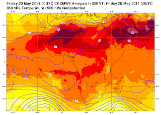
As the current upper level map by the European for Asia shows, the classic southern regions are hot and becoming hotter with the core centered over the NW India and Pakistan to the Arabian penninsula.
Showers and storms billow up around the outer rim of this heatwave. To the south, it's around the tropical coasts where South and Southeast Asia meet the Indian and southwest Pacific Ocean. Driving and instigated by warm, moisture-rich southerly winds off the Indian Ocean, daily thunderstorms develop when these winds blow onshore as this bouyant air is forced to rise. These thunderstorms ride these southerly winds only so far inland, to the point where the air becomes both too hot and too dry. Showers and storms manage to get further north where there are weaknesses in the high pressure cells and over the higher terrain.
On the northern side of the heat with always that focus over interior India, NW India and central and eastern Pakistan stretching across the Deserts of the Middle East, the Himalayas act as a natural barrier. These jagged peaks spike 20,000+ feet into the atmosphere, seperating the sub-continent with the rest of Asia, These west-east oriented mountains reach to jet stream level and seperate the extremely hot air of the sub-continent with very warm air to the north. Nepal, lies in between and here, they've seen persistent showers and thunderstorms.

What will ease the extreme heat over the sub-continent will be the northward progression of the ITCZ. This remains over the tropics but it's the very heat we're currently seeing further north that will help drive the ITCZ north and open up the 2011 India Monsoon. Once this happens, the heat is greatly reduced over northern India and Pakistan as the daily weather picture will eventually consist of daily showers and thunderstorms with torrential downpours. Areas north of the Himalayas will see hotter, sunnier conditions and the core of intense heat that's now over the northern sub-continent will be focused on the heart of the Arabian penninsula.

You can see clearly in the above upper level map from the European, where the hottest temperatures in all of the hemisphere are. In the middle map above, the highest pressures are actually showing a northward migration from a couple of weeks ago. Yes, the core of heat is beginning to push from the Sahel and Sub-Sahara north towards the southern Sahara Desert (southern Algeria, Libya etc). It's a slow process but it's happening.
This means that the thunderstorm belt or better known as the ITCZ (Inter Tropical Convergence Zone) is also lifting north. Once is generally still is, over the equatorial region of Africa and indeed over Indonesia and Malaysia, this band of west-east moving thunderstorms will be migrating north as the heat builds further north.
The signs are there with the 50C high today over Pakistan (the hottest temperature so far) and the height rises aiming at the Sahara Desert and lowering pressures over what has been the hottest region of Africa (Sahel and Sub-Sahara). This means the dry season is nearing an end and the wet season looms across the Sahel and Sub-Sahara.
WHAT'S REACHING TODAY'S BLOGS?
Can't Shake The Chances Yet...
Philly Weather.net
A brief break
Valley Weather (Montreal, QC Area)
Slave Lake Fires
Valley Weather (Montreal, QC Area)
THE EXTREMES OF THE DAY
TODAY'S US EXTREMES
COURTESY OF ACCUWEATHER
HIGH: 103 degrees at Laredo, TX
LOW: 18 degrees at Berthoud Pass, CO
TODAY'S UK EXTREMES
COURTESY OF THE MET OFFICE
HIGH: 68 degrees (20.1C) at Shoeburyness (Essex)
LOW: 36 degrees (2.1C) at Aviemore (Highland)
TODAY'S GLOBAL EXTREMES
COURTESY OF THE UNIVERSITY OF COLOGNE
HIGHEST
50C (122F) at Turbat & Jacobabad, Pakistan (Asia)
47C (117F) at Kiffa, Mauritinia (Africa)
46C (115F) at Doha, Qatar (Asia)
45C (113F) at I-n-Salah, Algeria (Africa)
LOWEST
-74C (-101F) at Vostok Station, Antarctica
-35C (-31F) at Summit Camp, Greenland
TODAY'S EXTREMES HERE AT MY HOUSE
HIGH: 54 degrees
LOW: 45 degrees
Thanks for reading.
-Mark


No comments:
Post a Comment