If you haven't already, click 'LIKE' on the WEATHER & CLIMATE THROUGH THE EYES OF MARK VOGAN blog FACEBOOK PAGE for regular 'on-the-road' updates, links to be biggest stories, photos and video thoughout the day, 7 days a week on your local, national and international weather.
TODAY'S TOP WEATHER STORIES
On Weather & Climate Through the Eyes of Mark Vogan
The Great Mississippi Flood 2011
morganza spillway flood situation, latest
Flooding covers millions of acres
CNN
Flood Evacuees Move Into Enclave Built for Katrina
FOX NEWS
15 miles of the flooded Mississippi River closed
CBS NEWS
IN OTHER NEWS TODAY
WILDFIRE ROARS THROUGH N. ALBERTA TOWN, DESTROYING MORE THAN HALF THE HOMES

More than 100 fires raging across Alberta
CBC EDMONTON
Wildfire Devastates Alberta Town
ACCUWEATHER.COM
TODAY'S WEATHER ACROSS UK & EUROPE By Mark Vogan
Windy day for Scotland tomorrow while two upper lows create issues over European mainland

With a trough digging back into Scotland again, after relaxing some and allowing a direct westerly flow in off the Atlantic, this will mean windier, cooler and wetter weather tonight for Scotland's Western Isles and coast. This potentially stormy weather will begin progressing eastward across Scotland over the course of tonight and into tomorrow. GALE FORCE winds will likely impact the Isles and western Highlands, perhaps even the western Central Lowlands by morning. A heavy, and at times persistent band of rain will progress west to east, heaviest in the west, starting now (late afternoon) and will push across the country, weakening as it crosses the Highlands and easing once in the east by midmorning tomorrow.

The central and southern areas of Britain will see showier and cooler weather than seen today and yesterday as a result of the tightening of the isobars to the north, dropping heights aloft and thus supporting less warm temperatures.
As for the European mainland, we're going to see some lively thunderstorms blossom in a fairly widespread fashion over the next few days across Iberia (Spain and Portugal) thanks to the influence of an upper low pulling NE from off the Morrocco coast into the south side of Iberia. With surface heating and the cool pocket in the upper levels, this will mean as the mornings wear on over the next few days, sunny skies will soon turn dark with plenty of thunder and lightning and torrential downpours. This weather will press north into northern Spain and southern France, bringing showers perhaps into the Alpine region over the next few days, easing by Thursday and Friday over the Alps and Italy.

Another upper low which has split off the main jet stream is drifting into the Greece and Turkey region. Again, like Spain, we're seeing warm surface temperatures and with the energy of an upper low aloft, we're also going to see lively weather over Greece and into Turkey. Across the open waters of the central, even eastern Med basin, we're likely to see showers and some rough swells with gusty winds blowing. These winds out of the west will pull showers into Cyprus and even into the western Middle East countrues of Israel, Syria, Iraq, especially over the mountainous areas.

All of mainland Europe will be very warm as the Spainish high expands northeastwards, helped by the southward push of the strong trough expanding from Iceland down into Scotland and the splitting away of the upper low over south-central Europe, the pressing of the trough and the southward movement of the upper low in the south-central region, opens a door in between for mid-20C air to spread across the majority of the mainland of the continent providing sunny skies. France, Germany, Poland all the way towards western Russia will see a plenty of sunshine and very warm conditions over the next several days, perhaps lasting into NEXT WEEK!
TODAY'S WEATHER ACROSS AMERICA By Mark Vogan
Cut-off low spins and spins bringing rain and rain to the East
When a low splits away from the prevailling westerlies, it not only does it take it's sweet old time leaving a given area but it can spwell problems for flooding.

The high to the north of the low means this system that is brining all the heavy rains this morning and through today has nowhere to go.

The fact we're seeing an extremely moist flow steaming from western Caribbean origin means 1-2 inches of precipitable water suspended in the atmosphere and this is flowing in the mid-levels up off the Virginia Capes and bending right into the Northeast. Add is a warm and already humid lower atmosphere and you've got the perfect set up fro tremendous downpours which can become very persistent.
In tomorrow's blog, I shall discuss this set up as well as the rest of the country's in detail, stay tuned!
WEATHER TALK AFRICA, MIDDLE EAST & W. ASIA By Mark Vogan
Middle East Deserts to see the heat crank in a big way with Kuwait City possibly aiming for 121 degrees

With the exceptions of some spots across the Deserts of Kuwait, Iraq, Oman, Syria, Iran and other countries reaching 111F (44C), most other desert cities have seen relatively cool temperatures for this time of year. In part, this is thanks to showers, t-storms and fairly low pressures aloft for a region that's typically hotter than the upper 90s F or upper 30s C during early into mid-May, However, this is about to change as in the coming days, showers and t-storm chances deminish as does clouds, some spots may remain under t-storm threats but as pressures rise, this should erode the atmosphere's ability to produce cloudiness. Rising pressures will rise surface temperatures well above 100F (38C) for all but high elevation mountains. Some of the classic hot spots will likely push 120F with Kuwait City and Basra, Iraq hot contenders as well as a few spots in Saudi Arabia. Baghdad, which has been cool and showery of late will likely see highs reach over 111F over the next few days. Much more typical for mid to late May in a region that rivals the hottest places on earth.
WHAT'S REACHING TODAY'S BLOGS?
Location, Location, Location - Weather Varieties within a Storm
Joe Lundburg, AccuWeather
It's Van Gundy Season ... Take Two
Frank Strait, AccuWeather
THE EXTREMES OF THE DAY
TODAY'S US EXTREMES
COURTESY OF ACCUWEATHER
HIGH: 100 degrees at Dryden, TX
LOW: 15 degrees at Bodie State Park, CA
TODAY'S UK EXTREMES
COURTESY OF THE MET OFFICE
HIGH: 67 degrees (19.5C) at Shoeburyness (Essex)
LOW: 40 degrees (4.3C) at Aboyne (Aberdeenshire)
TODAY'S GLOBAL EXTREMES
COURTESY OF THE UNIVERSITY OF COLOGNE
HIGHEST
49C (120F) at Noorpurthal, Pakistan (Asia)
47C (117F) at Maghama, Mauritania (Africa)
47C (117F) at Hombori, Mali (Africa)
46C (116F) at Gangangar, India (Asia)
44C (111F) at New Delhi, India (Asia)
41C (106F) at Monterrey, Mexico (North America)
LOWEST
-75C (-103F) at Vostok Station, Antarctica
-20C (-4F) at Summit Camp, Greenland
-12C (10F) at Iqaluit, Baffin Is, Canada
-19C (-2F) at Stefansson Is, NWT, Canada (North America)
TODAY'S EXTREMES HERE AT MY HOUSE
HIGH: 58 degrees
LOW: 46 degrees
Thanks for reading.
-Mark
TODAY'S TOP WEATHER STORIES
On Weather & Climate Through the Eyes of Mark Vogan
The Great Mississippi Flood 2011
morganza spillway flood situation, latest
Flooding covers millions of acres
CNN
Flood Evacuees Move Into Enclave Built for Katrina
FOX NEWS
15 miles of the flooded Mississippi River closed
CBS NEWS
IN OTHER NEWS TODAY
WILDFIRE ROARS THROUGH N. ALBERTA TOWN, DESTROYING MORE THAN HALF THE HOMES

Burned-out vehicles sit in a destroyed neighbourhood of Slave Lake, Alta., on Monday after a wildfire swept the town. (Todd Korol/Reuters)
More than 100 fires raging across Alberta
CBC EDMONTON
Wildfire Devastates Alberta Town
ACCUWEATHER.COM
TODAY'S WEATHER ACROSS UK & EUROPE By Mark Vogan
Windy day for Scotland tomorrow while two upper lows create issues over European mainland

The above surface map shows the European's version of the current surface map over Europe. As you can see, it shows a rather strong surface low NW of Scotland, 'These heights associated with this trough is crossing Highlands Scotland, the Central Lowlands lie in the boundary between low/high pressures.' Note the low off SW Iberia, this is the show and t-storm trigger and also the cut off low over southern Greece.

The above map shows surface pressures 12 hours from now, the low and trough has now deepened and positioned closer to Scotland, isobars (blue lines) are tighter together and run west-east across Scotland and well into central England. These tightly packed isobars suggest strong winds blowing 12 hrs from now. Also notice pressures building across western Europe's mainland, the low, once off Portugal is now fingering into the SW Iberia, likely enhancing shower and t-storm development and keeping temps at bay but rising them to the N and E of Madrid. The low over Greece hasn't really moved much due to the fact it's detached itself from the main upper flow.
The central and southern areas of Britain will see showier and cooler weather than seen today and yesterday as a result of the tightening of the isobars to the north, dropping heights aloft and thus supporting less warm temperatures.
As for the European mainland, we're going to see some lively thunderstorms blossom in a fairly widespread fashion over the next few days across Iberia (Spain and Portugal) thanks to the influence of an upper low pulling NE from off the Morrocco coast into the south side of Iberia. With surface heating and the cool pocket in the upper levels, this will mean as the mornings wear on over the next few days, sunny skies will soon turn dark with plenty of thunder and lightning and torrential downpours. This weather will press north into northern Spain and southern France, bringing showers perhaps into the Alpine region over the next few days, easing by Thursday and Friday over the Alps and Italy.

The above map shows the 2M temperatures for tomorrow PM
Another upper low which has split off the main jet stream is drifting into the Greece and Turkey region. Again, like Spain, we're seeing warm surface temperatures and with the energy of an upper low aloft, we're also going to see lively weather over Greece and into Turkey. Across the open waters of the central, even eastern Med basin, we're likely to see showers and some rough swells with gusty winds blowing. These winds out of the west will pull showers into Cyprus and even into the western Middle East countrues of Israel, Syria, Iraq, especially over the mountainous areas.

The above map is the 2M temperature map for Thursday PM, not the orange colours from the previous map as high pressures builds and expands, covering pretty much all of mainland Europe, leaving the UK cool beneath the trough.
All of mainland Europe will be very warm as the Spainish high expands northeastwards, helped by the southward push of the strong trough expanding from Iceland down into Scotland and the splitting away of the upper low over south-central Europe, the pressing of the trough and the southward movement of the upper low in the south-central region, opens a door in between for mid-20C air to spread across the majority of the mainland of the continent providing sunny skies. France, Germany, Poland all the way towards western Russia will see a plenty of sunshine and very warm conditions over the next several days, perhaps lasting into NEXT WEEK!
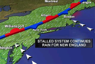
TODAY'S WEATHER ACROSS AMERICA By Mark Vogan
Cut-off low spins and spins bringing rain and rain to the East
When a low splits away from the prevailling westerlies, it not only does it take it's sweet old time leaving a given area but it can spwell problems for flooding.
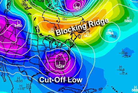
This colorful map shows well the cut off low and the banana high over top. This is also known as an Omega-Block.
The high to the north of the low means this system that is brining all the heavy rains this morning and through today has nowhere to go.
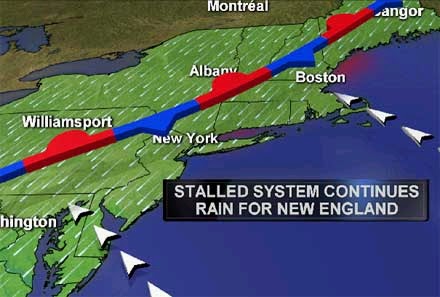
This map from TWC shows the nature of this current pattern. the stalled front means moist flow persistently coming in off Atlantic provides persistent rains for Northeast.
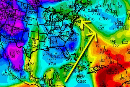
The above map shows ( with yellow arrows) the tropical flow coming up from the western Caribbean.
The fact we're seeing an extremely moist flow steaming from western Caribbean origin means 1-2 inches of precipitable water suspended in the atmosphere and this is flowing in the mid-levels up off the Virginia Capes and bending right into the Northeast. Add is a warm and already humid lower atmosphere and you've got the perfect set up fro tremendous downpours which can become very persistent.
In tomorrow's blog, I shall discuss this set up as well as the rest of the country's in detail, stay tuned!
WEATHER TALK AFRICA, MIDDLE EAST & W. ASIA By Mark Vogan
Middle East Deserts to see the heat crank in a big way with Kuwait City possibly aiming for 121 degrees

With the exceptions of some spots across the Deserts of Kuwait, Iraq, Oman, Syria, Iran and other countries reaching 111F (44C), most other desert cities have seen relatively cool temperatures for this time of year. In part, this is thanks to showers, t-storms and fairly low pressures aloft for a region that's typically hotter than the upper 90s F or upper 30s C during early into mid-May, However, this is about to change as in the coming days, showers and t-storm chances deminish as does clouds, some spots may remain under t-storm threats but as pressures rise, this should erode the atmosphere's ability to produce cloudiness. Rising pressures will rise surface temperatures well above 100F (38C) for all but high elevation mountains. Some of the classic hot spots will likely push 120F with Kuwait City and Basra, Iraq hot contenders as well as a few spots in Saudi Arabia. Baghdad, which has been cool and showery of late will likely see highs reach over 111F over the next few days. Much more typical for mid to late May in a region that rivals the hottest places on earth.
WHAT'S REACHING TODAY'S BLOGS?
Location, Location, Location - Weather Varieties within a Storm
Joe Lundburg, AccuWeather
It's Van Gundy Season ... Take Two
Frank Strait, AccuWeather
THE EXTREMES OF THE DAY
TODAY'S US EXTREMES
COURTESY OF ACCUWEATHER
HIGH: 100 degrees at Dryden, TX
LOW: 15 degrees at Bodie State Park, CA
TODAY'S UK EXTREMES
COURTESY OF THE MET OFFICE
HIGH: 67 degrees (19.5C) at Shoeburyness (Essex)
LOW: 40 degrees (4.3C) at Aboyne (Aberdeenshire)
TODAY'S GLOBAL EXTREMES
COURTESY OF THE UNIVERSITY OF COLOGNE
HIGHEST
49C (120F) at Noorpurthal, Pakistan (Asia)
47C (117F) at Maghama, Mauritania (Africa)
47C (117F) at Hombori, Mali (Africa)
46C (116F) at Gangangar, India (Asia)
44C (111F) at New Delhi, India (Asia)
41C (106F) at Monterrey, Mexico (North America)
LOWEST
-75C (-103F) at Vostok Station, Antarctica
-20C (-4F) at Summit Camp, Greenland
-12C (10F) at Iqaluit, Baffin Is, Canada
-19C (-2F) at Stefansson Is, NWT, Canada (North America)
TODAY'S EXTREMES HERE AT MY HOUSE
HIGH: 58 degrees
LOW: 46 degrees
Thanks for reading.
-Mark


No comments:
Post a Comment