Follow this blog on Facebook and Twitter and become a Fan!
Today's Top Weather Stories
On Weather & Climate Through the Eyes of Mark Vogan
MAIN STORY
NOAA Expects Busy Atlantic Hurricane Season
NOAA
Related Stories:
pennsylvania, u.s.a
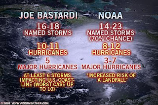
How Does Joe Bastardi's Hurricane Forecast Compare to NOAA?
AccuWeather
guatemala, central america
Eastern Pacific Tropical Development
AccuWeather
pennsylvania, u.s.a
VIDEO: The La Nina is NOT the Driving Force for the Hurricane Season!
Joe Bastardi, Chief Long-Range Forecaster, AccuWeather
other stories
guatemala, central america
Deadly Guatemala Volcano Spews Ash, Closes Airport
AccuWeather
trinidad, caribbean
VIDEO: The Caribbean Goes from Drought to Floods
AccuWeather
florida, u.s.a
Dr. Beach Picks 2010's Best Beaches In America
CBS 4 Miami
england, europe
Four injured in lightning strikes in Cumbria
BBC Weather
england, europe
Jersey's water supply drops following dry spring
BBC Weather
Today's Weather across America
From AccuWeather
The Northern Plains to Face Violent Thunderstorms
AccuWeather
VIDEO: The Worst Oil Spill in US History
AccuWeather
Extreme Weather: Carolina's Hail and Wind. Plains Storms
Henry Margusity, AccuWeather
Weather Talk
By Mark Vogan
NOAA Joins the "Very Active" Hurricane Season band wagon
The similarities between this year and 2005 could not be more in line, with the vast majority of the tropical Atlantic between 1-3 degrees above normal and now the Gulf is generally 1 degree above normal, that's after a very cool Gulf back earlier in the spring and late winter. The cool Gulf was a result of the harsh southern US winter but indeed the reversal to warm is striking and may well be as much as 3 degrees or more above normal a month from now.
The amount of organisations now calling for a much above normal season is alarming and I fear without trying to scare monger or even hype things up, the potential is there for another Katrina-like storm to form over the Gulf, in a similar place to where Katrina blow it's top. That loop current may well play the biggest role in a hurricane season since 2005 and is showing signs that it's alive and kicking. Run a hurricane through there this year with waters 1-5 above normal across the entire basin and then into the Gulf which may be 2-4 above normal and we have another Katrina or Rita scenario all over again.
New Orleans didn't see worst case with Katrina
We all must remember that as bad as Katrina was, it wasn't a worst case, it possibly was for the Mississippi Gulf Coast purely because of that 30-foot surge but certainly not in terms of wind speed which may have been as low as cat 2 intensity at landfall. Katrina's size and power the day before it came ashore was the reason why there was so much devastation.
What is more worrying is that if we carry a cat 4-5 all the way to the coast thanks to the position of the loop current, then we're going to see the Gulf Coast residents in serious trouble as winds may be sustained at over 150 to 160 mph with gusts to 200 mph as it blows ashore.
It happened back in 1969 with Camille because that storm ran along the loop current until it reached shore.
Instead of reading this and thinking, Mark Vogan is trying to scare, look at it as pointing out what "could happen" and therefore more may take these forecasts more seriously when things are pointed out.
I'm in the belief that folks aren't going to pay as much attention to a forecast that calls for over 18 storms, but more so when it's directly shown to them that, here's the type of set-up we have across the hurricane zone and he're the type of storms this pattern may produce.
2010 is a season that may produce Andrew's, Katrina's Rita's and Camille's. Katrina, Rita and Wilma where all powerful hurricanes at their peak, but the key to them all was that they hit their peak well offshore, but what the public needs to understand is that, that is why residents that have been directly effected back hurricanes in the last 10 years saw a "weakening storm" as it moved over them. We need to see preperation for an Andrew, Camille or even Charley type scenario where they peaked at landfall and caused utter chaos to millions.
I dissagree with one person whom I heard say in the past couple of days that Katrina was a once in a lifetime, unfortunately another Katrina type storm is likely in the Gulf over the next 10-20 years I believe. All you need is a storm, with a similar track and the Gulf and the atmosphere above to be in the same condition as it was in 2005 and you have the same scenario unfold all over again, if not worse.
What's Reaching Today's Blogs?
Less Amplitude Means More Warmth
Joe Lundburg, AccuWeather
Severe Thunderstorms in Pennsylvania Yesterday
Jesse Ferrell, AccuWeather
Heat Index over 100F
Valley Weather Blog, Montreal, QC
Comparing NOAA's Hurricane Forecast to Others
Northeast Quadrant
Today's US Extremes
Courtesy of AccuWeather
High: 97 degrees at Terrell, TX
Low: 13 degrees at Bodie State Park, CA
Today's Extremes here at my house
High: 59 degrees
Low: 42 degrees
Thanks for reading.
-Mark
Subscribe to:
Post Comments (Atom)


No comments:
Post a Comment