TODAY'S TOP WEATHER STORIES
On Weather & Climate Through the Eyes of Mark Vogan
SEE WEATHER TALK BELOW: SNOW POSSIBLE WITHIN THE GLASGOW TO EDINBURGH CORRIDOR AS WELL AS OVER THE PENNINES, SNOWDONIA LATER TONIGHT AND TOMORROW MORNING...
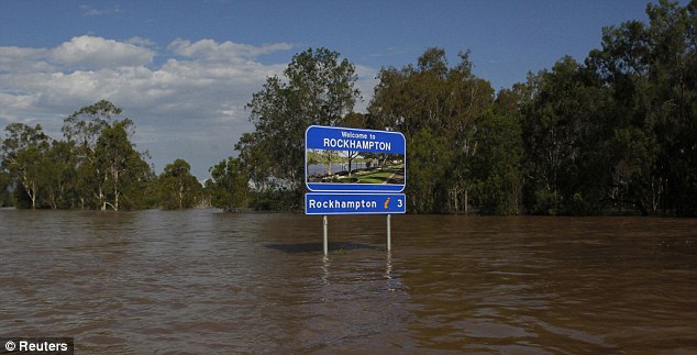
QUEENSLAND, AUSTRALIA
AREA THE SIZE OF FRANCE AND GERMANY COMBINED IS UNDERWATER!

Emergency officials patrol a flooded highway in Rockhampton, Australia. (Image Courtesy of CNN)
Evacuations in Australia proceed as floodwaters rise
CNN
Raging waters, snakes keep residents away
ABC Australia News
Today's ABC Australia Forecast
Queensland floods: Rockhampton braces for flood peak
BBC
Sewage, snakes and looters: Triple terror facing Australians cut off by floods as waters keep on rising
Daily Mail
Nina Ridge brings the BBC Australia Weather Forecast
For the homeless, winter is colder and wetter
Los Angeles Times
TODAY'S WEATHER ACROSS AMERICA
From AccuWeather

BASTARDI: January Could Be Coldest For US Since 1980s
By Heather Buchman, Meteorologist
Is Worst of Winter Over?
By Heather Buchman, Meteorologist
Snow Falling Over the Great Lakes
By Katie Storbeck, Meteorologist
WEATHER TALK
By Mark Vogan
UK Latest Weather
COOLER AIR ONCE AGAIN DRAWING IN ACROSS UK, SNOW POSSIBLE FOR LOWLANDS OF SCOTLAND AS WELL AS ACROSS THE SOUTHERN UPLANDS, SNOWDONIA AND THE PENNINES TONIGHT AND TOMORROW
It seems as though everytime we watch the evening weather forecast, there's literally always mention of snow, even at low levels "for a time" before turning to rain. Yes, it's a pattern which is seeing the fight continue between milder Atlantic air pushing in on board southwest winds but because cold air is still nearby and we never really get a total Atlantic airmass covering us. When frontal systems push in off the Atlantic, those southwest winds make that turn once the front has pushes through and we then see that air come in from either the north or the east, thus we're periodically seeing rain, which has been fairly persistent, here in the central part of Scotland change to sleet and over slightly higher terrain, to fully snow.
As yet another front pushes through, rains may change to snow tomorrow morning over the Glasgow to Edinburgh corridor for a time, perhaps providing a slushy coating whilst higher ground over Ayrshire, South Lanarkshire and out towards the Lothians and Borders, a decent covering may occur. The same may happen further south over the Cumbrian Fells as well as down the spine of English Pennines and over across Snowdonia. For a time, cities such as Carlisle, Manchester, York, even Newcastle may see snow as the initial push of cooler is blows in from Scotland as overnight temperatures fall away fast.
ICING RISK INCREASES AS GROUND REMAINS VERY WET FOR EVERYONE AND TEMPERATURES DROP AWAY TONIGHT
Because there will be a fresh injection of cooler air (not so much COLD when comparing to recent times) and the ground has been soaked well by a series of frontal systems, icing will become more and more of a hazard both tomorrow morning for northern areas as the cool air will arrive first, on the backside of a rain/snow producing weather front that's moving south and in more central and southern areas later tomorrow and into Thursday morning. By Thursday morning after even low level areas see it snow again, skies will clear out and temperatures instead of being in the 4-7C range today may be closer to 2-3C tomorrow from Glasgow to Edinburgh and those levels in Manchester to Birmingham Thursday with nighttime lows drifting back below freezing. All that moisture on the ground which has struggled to be absorbed by frozen ground will then freeze.
AMERICA SET FOR BRUTALIZING COLD NEXT WEEK! DETAILS COMING TOMORROW!
This morning's national lows

Queensland Flood In Photo's
Photo's Courtesy of the Daily Mail

Submerged: Depot Hill in Rockhampton is badly hit by the worst flooding in a decade

Rescue: An emergency services worker wades through the Capricorn Highway. Three people have so far been killed in the disaster

Under water: And aerial picture shows the extent of the floods
Under water: All the roads, train stations and airports have been closed in Rockhampton - and residents have been warned not to enter the water


Slippery customer: A snake slithers across the Capricorn Highway. Residents have been warned to look out for crocodiles and snakes in rising floodwaters
VAGARIES OF THE WEATHER
INDIA & SUB-CONTINENTAL ASIA WEATHER
BY RAJESH KAPADIA
Coming Soon!
WHAT'S REACHING TODAY'S BLOGS?
Weather Extremes Not Letting Up
Joe Lundburg, AccuWeather
Radar: 4K and 20 Blackbirds Downed From The Sky
Jesse Ferrell, AccuWeather
THE EXTREMES OF THE DAY
TODAY'S US EXTREMES
COURTESY OF ACCUWEATHER
HIGH: 86 degrees at Edinburg, TX
LOW: -29 degrees at Orr, MN
TODAY'S UK EXTREMES
COURTESY OF THE MET OFFICE
HIGH: 50 degrees (10.2C) at Isles of Scilly
COLD HIGH: 36 degrees (2.2C) at High Mowthorpe (Yorkshire)
LOW: 19 degrees (-7.1C) at Sennybridge (Powys)
TODAY'S EXTREMES HERE AT MY HOUSE
HIGH: 41 degrees
LOW: 33 degrees
Thanks for reading.
-Mark


No comments:
Post a Comment