On Weather & Climate Through the Eyes of Mark Vogan
Travelling along the snowcovered Crawfordjohn road which links the A76 with the M74 this afternoon. Truck temp as of 1pm was reading -4C near Douglas, South Lanarkshire. At 4am this morning whilst heavy snow showers were progressing through the central belt, my truck temp was reading -9C near Happendon services.
ARCTIC BRITAIN.....
Heavy, persistent bands of snow cripple transport network across Britain for fourth straight morning rushhour, Forth Road Bridge and Edinburgh Airport shutdown. Altnaharra plummets to -21C, will be colder tonight!

live news feed...
As of 5pm, Altnaharra, Sutherland is already reading -15.7C!
LATEST NEWS FROM ACROSS SNOWBOUND UK
Snowfall is Scotland's 'worst' for more than 40 years
STV Scotland
Forth bridge reopen to all vehicles
The bridge reopened at 3pm after snow closed it for the first time in living memory.
STV Scotland
In today's UK Newspapers
Millions endure second nightmare journey home from work as forecasters predict EIGHT INCHES of snow tonight
The Daily Mail
UK snow: Arctic conditions hit travel networks
The Daily Telegraph
All SPL games this weekend wiped out by the winter weather
The Daily Record
Edinburgh council staff work 'flat out' to keep capital moving in worst snowfall since 1963
The Daily Record

Workmen clear snow from the car park at Edinburgh Airport, which has been forced to close today
Image Courtesy of The Daily Mail
Today's Weather across America
From AccuWeather

Colder Air Begins its Push
AccuWeather
High Winds, Flooding, Thunderstorms Target New England Wednesday Night
AccuWeather
Weekend Snowstorm for the Midwest
AccuWeather
Weather Talk
By Mark Vogan

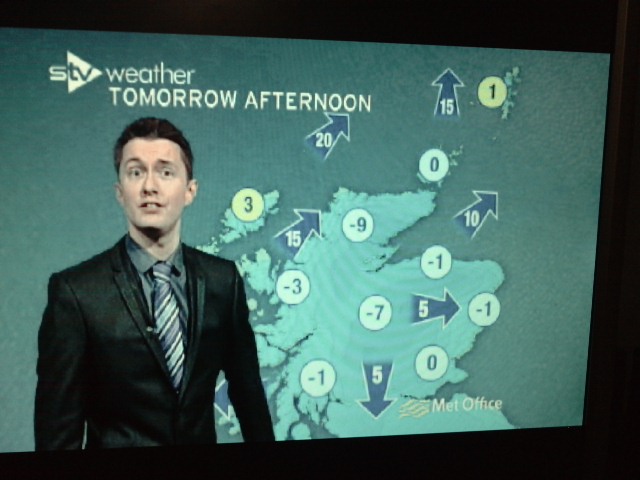
STV
Altnaharra under the Arctic high, Aviemore partly under Arctic high and Central Belt on tail end where winds circling the high is feeding persistent snowbands in off North Sea
PERSISTENT, UNRELENTING SNOWFALL FROM ABERDEEN TO EDINBURGH TO GLASGOW LIKELY DUE TO EARLY TIME OF YEAR, WARMER NORTH SEA TEMPERATURES AND THE EXTREME AIR MASS OVERHEAD FOR SO EARLY ON.

STV
It just seems it wants to snow, snow and snow doesn't it. After 4 straight mornings with snow snarling rush hour and low temperatures creating icing problems also, I turn my thoughts to why so much snow?
Well, 1) it's very early on in the year for an Arctic air mass which doesn't usually penetrate this far south, this early, 2) the shear power of this Arctic air mass, the position of the high pressure cell which is now sitting just north of Caithness, thus presenting Altnaharra with remarkable cold for late November/early December but is also throwing northerlies down across the heart of Scotland. 3) As those extremely cold winds blow over the still relatively warm waters of the North Sea, heavy snows have broken out... It's really all to do with the fact that the Arctic high is first and foremost as unusually strong as it is and it's KEY position which is perfectly aligned to bring those harsh northeast winds blowing across the warm North Sea waters and onshore along the Moray, Aberdeenshire, Angus, Fife, Edinburgh and the Lothians and Borders coast pasting them with persistent snows and simply because those winds have been persistent. As the heavy snows ride the strong northeast flow, they upslope the higher terrain stretching from Moray all the way down to the Pentland Hills and Southern Uplands and thus heavier snow accummulations as well as blowing and drifting as the upslope creates a phenonomen known as orographic lift. As winds ride up the windward sides of mountains, they cool, condense and produce more moisture and therefore more snow. This is why the heart of the Grampians, Cairngorms and even the higher ground of the Lothians and Borders and across into the heart of the central belt has seen most snow.
Even the Glasgow area, though hasn't seen near as much as further east and north, this area has seen it's fair share with my house tonight reporting a 7 and a half inch snowbase as persistent snows have came and went and dropped in and around an inch each time.
STV
At this present time, the northwest Highlands are now enduring severe cold as winds have lightened up, skies cleared out and the core of cold is closest, therefore explaining why Altnaharra dropped to -21C for the low. As for Aviemore, their slightly away from that core, thus snow showers still come and go and temps are not quite as cold. However by tomorrow evening, lows may dip towards -20C at both Aviemore and Braemar as the core of coldest air gets closer. The heart of the central lowlands which have been very cold in between those snowshowers with lows dipping to -7C in Glasgow, both clouds and snow have came and went too often and therefore temps haven't been able to fall too far. Again, as Aviemore gets a chance at -20C or lower tomorrow night, Glasgow and Edinburgh will have a chance to see longer spells of clear skies and much lighter winds and with all that deep, fresh snowcover, -10C is very plausible whilst even lower readings are possible out in rural areas.
In the coming days, as snows become much less frequent in the east, daytime highs will become downright frigid as highs in Livingston and Edinburgh may struggle to get above -6C and lows may even drop towards -12 to -15C as the high continues drifting southwards. Even Glasgow all the way south to Dumfries may see extremely low reading by Friday and Saturday! Stay tuned.
What's Reaching Today's Blogs?
Severe Weather Heading into NYC
Henry Margusity, AccuWeather
Non-Winter Stats Update: Winter is Here
Jesse Ferrell, AccuWeather
The Extremes of the Day
Today's US Extremes
Courtesy of AccuWeather
High: 86 degrees at Fort Lauderdale, FL
Low: -10 degrees at Chinook, MT
Today's UK Extremes
Courtesy of the Met Office
High: 39 degrees (3.7C) at Isles of Scilly
Cold High: 11 degrees (-11.5C) at Altnaharra (Sutherland)
Low: -6 degrees (-21.1C) at Altnaharra (Sutherland)
Today's Extremes here at my house
High: 32 degrees
Low: 24 degrees
TODAY'S CONDITIONS
Snowcover: 7.5 inches
A generally cold feeling day with off and on snow showers.
Thanks for reading.
-Mark


No comments:
Post a Comment