TODAY'S TOP WEATHER STORIES
On Weather & Climate Through the Eyes of Mark Vogan
Duststorms Sweep Iraq
ACCUWEATHER NEWS
TODAY'S WEATHER ACROSS UK & EUROPE By Mark Vogan
April Showers to pepper UK through rest of this week, much of northwest joins Scandinavia and eastern Europe in chilly, unsettled weather regime
Today, like yesterday was a cool day made cooler by a stiff west wind blowing across Scotland and much of northern Britain. Those westerly winds have been blowing in hefty vigorous April showers throughout today with gloriously sunshine in between, some of those showers were intense, producing stinging hail and I would be surprised if some up over the higher terrain of the Highlands/Southern Uplands didn't produce some thunder and lightning, even hill snow as this air being transported in from the northwest is pretty chilly indeed.
Warmth that was over UK has been shoved south to where it came from!
This much colder air mass that has driven out our flirt with summer is making it's way well into western Europe, shaving as much as 10C off yesterday's highs across a broad area penetrating deep into Germany, Poland etc. Places like Copenhagen, Rotterdam, Paris, Brussels, eastwards into Berlin and Warsaw that enjoyed 18 to 24C highs and bright sunshine, found themselves shivering in highs barely making it to 10C along with a gusty, stinging northwesterly wind.
Where has all the warm air gone to? That air mass has been squeezed back south into central and southern Spain and Portugal where the sun shines and highs continue to warm into the upper 20s to even low 30s C (low 90s F).
The pattern remains unsettled and Atlantic driven for much of the remainder of this week across Britain, northern and central France, eastwards through the Low Countries of Holland, Belgium into Germany. Models do suggest a retrogration of the new western trough as the Spain high try to nudge back north towards the UK. More that in tomorrow's post!
TODAY'S WEATHER ACROSS AMERICA By Mark Vogan
Summer not ready for US just yet despite yesterday's heat and humidity in East
It's a rainy, much cooler day across Northeast, Mid-Atlantic
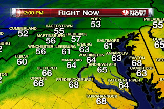
The contrast between today with yesterday at this time couldn't be greater from DC north to Boston. Whilst highs topped the upper 80s throughout Greater DC-Baltimore, low 80s for Philly, low to upper 80s throughout the Greater NYC area and low to mid-70s for the Greater Boston area, today that front that's been trekking distructively eastwards since Saturday has now reached the big cities of the I-95 corridor and has now erased the one-day warmth for this region. Thanks to low pressure forming, the front has stalled out and today we'll see plenty of clouds and rain along with highs only making it into the 60s from DC to Boston. A little warmer air over DC and Philly may see some peaks of sun, enough to boil up the atmosphere a little making for some thundery downpours, but it may also become very overcast and showers. Throughout the region it will be mainly overcast, rainy and cool. This rainy, cool pattern will remain well into tomorrow and unfortunately, despite clearing of those clouds in the coming days, temperatures won't get back into those beautiful 80s for a little while yet.
Check out the DC area's difference in temperature this afternoon as compared with around 24 hours ago at this time yesterday!
Yesterday PM
This PM
Snow & Cold Weather ahead for Northern Plains in coming days!
More tomorrow!
WEATHER TALK
By Mark Vogan
I saw the Northern Lights 40,000 feet above Greenland en-route to Amsterdam from Chicago in February 2008
This photographic timelapse video captured is a work of art!
The Haves and Have-Nots Won't Be Trading Places Any Time Soon
Joe Lundburg, AccuWeather
Here Comes the Next Storm with Snow and Severe Weather
Henry Margusity, AccuWeather
new: what's on today's weatherbell blogs?
More fun with the upcoming hurricane season
Joe Bastardi's Blog, Weatherbell.com
The September Surprise – The Great Hurricane of ’38
Joe D'Aleo's Blog, Weatherbell.com
THE EXTREMES OF THE DAY
TODAY'S US EXTREMES
COURTESY OF ACCUWEATHER
HIGH: 93 degrees at West Palm Beach, FL
LOW: 11 degrees at Springerville, AZ
TODAY'S EXTREMES HERE AT MY HOUSE
HIGH: 52 degrees
LOW: 33 degrees
Thanks for reading.
-Mark


No comments:
Post a Comment