Haven't seen my Winter Forecasts for the UK, Europe as well as US? CLICK HERE!
Today's Top Weather Stories
On Weather & Climate Through the Eyes of Mark Vogan

Rogue Storm Slams New England
AccuWeather News
The strongest wind gusts observed Monday during the storm include: 63 mph at Portland, Maine; 58 mph at East Milton, Mass.; 53 mph at Providence, R.I.; 49 mph at Springfield, Vt.; 49 mph at White Plains, N.Y.; 45 mph at Bridgeport, Conn.; and 43 mph at Portsmouth, N.H.

Stranded: The Hjaltland was due to dock at 7am on Monday.
Image Courtesy of STV
Stranded ferry diverted from Aberdeen to Rosyth
STV Weather
Severe weather warnings as UK battered by storms
BBC Weather
San Juan on Pace to Break Yearly Rain Record
AccuWeather News
Two More Tropical Threats to India in Next 10 Days
AccuWeather News
Today's Weather across America
From AccuWeather
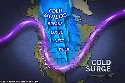
November Arctic Cold Blast Forecast
By Alex Sosnowski, Expert Senior Meteorologist
Outlook for Veterans Day Memorials
By Meghan Evans, Meteorologist
First Snow of the Season Hits Southern New England
By Heather Buchman, Meteorologist
Cascades, Sierra Nevada Snowstorm Tuesday
By Alex Sosnowski, Expert Senior Meteorologist

Weather Talk
By Mark Vogan

INCREDIBLE WARMTH SPREADS THROUGH THE PLAINS AS RAPID CITY TOPS 76, CHICAGO 67 AND EVEN INTERNATIONAL FALLS TOPS 62!
What's going on? Isn't it November 8th? Well, it is and it's not only stormy on both West and East coasts but very warm in between. It's actually the two pin-wheels spinning on both coasts that's propelling all the Gulf Coast-like late in the year heat all the way to the US-Canada border where we've seen basically shorts and t-shirt weather all the way to International Falls, Minnesota where the high peaked at 62 degrees today.
The low of 43 degrees at Minneapolis this morning was WARMER than the average high is for November 8th and WCCO-TV meteorologist Mike Augustyniak did his 5am weather report outside and yes WITHOUT a jacket!
It was colder this morning in north Florida (33 degrees at Jacksonville) than it was at International Falls at 35 degrees!!

Tomorrow may turn out even warmer for Minneapolis and Chicago with a run at 70 degrees!

Those numbers on the Weather Channel map above may be too low believe it or not for both midwest cities as the storm system that will produce a snowstorm over the Sierra and Rockies tomorrow will slowly progress east, allowing strong south winds out ahead of it's main frontal system over the Plains to blow out of the south and thus shove warmer tropical air to be forced north and this setup will be perfectly aligned for Minneapolis and Chicago to recieve very warm air tomorrow afternoon under sunshine and temperatures may should appraoch 70 degrees, and there's an actual chance that O'Hare and MSP airports actually top that glorious 70-degree mark.
COLDER WEATHER DOES LIE AHEAD!
Yes, this unseasonable warmth covering the Midwest won't last as that storm system out to the west will arrive later this week, driving tempeartures back closer to normal rather than 20+ degree above normal... The storm system over the Northeast will also depart and thus the warmth over the Plains will be erased but will likely bring warmth towards the East Coast!
UK Latest Weather
WILD NIGHT OF WEATHER AT MY HOUSE! TORRENTIAL RAINS TO START THE DAY TUESDAY OVER THE SOUTH COAST OF ENGLAND!
After a day which saw a brisk east wind and hefty showers, tonight has turned downright nasty with a howling east to northeast wind and torrential downpours which have accompanied the near gale-force gusts of wind that are blowing outside and battering my northfacing windows with a nasty three-way combo of cold, wind and driving rains.
An area of strong low pressure is drifting south of here and thus contributing to the nasty night of weather. That easterly wind is making it feel bitter to be outside and is also producing snow over the higher ground. It's likely that snow is falling over the Pennines this evening as well as over the Grampians and despite it being in the modest low 40s tonight here, I wouldn't be at all surprised if the Campsie Fells, which I look at over to the north of my house, if there was snow falling aboard those strong east, northeast winds and even was lying on the atop those hills by daybreak tomorrow. Reports have suggested that snow has been falling throughout the day over Drumnochter Pass on the A9, just south of Dalwhinnie in the Highlands, no surprise there of course! It even snowed along the M74 (the main artery which links Scotland with England) to the north of Moffat where the road climbs up from the flats of the Solway Plain, at the border. It's likely, it snowed at the stretch between Beattock Summit and Abington where it's high and remote as the road cuts through the Southern Uplands!
SOUTH COAST COUNTIES TO FACE TORRENTIAL, WIND DRIVEN RAINS FOR MORNING RUSH ON TUESDAY, LONDON RESIDENTS MAY FIND THEMSELVES IN THE SAME BOAT!
After a showery day Monday over Greater London and the south with a substantial trim back in temps from last weeks values. Winds will pick up overnight like they have here in the Lowlands of Scotland as the strong low continues southbound. This shift south will force winds to roar over East Anglia as well as the Kent and Sussex coasts bringing bands of rain in which are embedded within the low's circulation. These rain bands will likely have a "training" nature, meaning one band after another will run along the same areas and thus presenting areas of the southeast of England as well as the south coast with flooding issues. To make matters worse those winds which are likely to roar up the Thames estuary and into London may be strong and gusty with gales further down the estuary and nearer the North Sea, but they'll be cold feeling and will drive heavy rains in for the morning rush hour!
Vagaries of the Weather
India & Sub-Continental Asia Weather
By Rajesh Kapadia

Monday, November 08, 2010
Scene shifting to the West coast.
The remnant of "Jal" is now a low pressure, with 1002 mb and located at 15.3N and 75E, almost at Goa.
This low pressure seems likely to re emerge into the Arabian Sea off the S.Konkan/Goa /N.Karnataka coast by tomorrow, 9th.
Though it will be at around 1004 mb, not very deep, the UAC associated with with this System at Mid-Upper Level will precipitate rains.
The rains will be concentrated in the Konkan/Goa and South Mah. regions initially on the 9th.
Later, the NCEP GFS shows the UAC is expected to move NW, and along with
the sea level low, move into the Saurashtra peninsula. System should precipitate fairly heavy unseasonal rains in the Saurastra region and N.Gujarat around the 10/11th.
Rainfall is expected to creep into S.Rajasthan and west M.P.
Mumbai forecast remains unchanged.
A system expected to enter Andaman Sea around 13th. Vagaries will keep up dating as and when.
FOR GREAT INDIA, SUB-CONTINENT ASIA AND GLOBAL WEATHER NEWS
See our partner's blog in-full CLICK HERE!
What's Reaching Today's Blogs?
Moisture From Tomas Feeds Into Coastal Storm
Jesse Ferrell, AccuWeather
The Drumbeat of Winter Grows Ever Louder
Joe Lundberg, AccuWeather
First Coastal New England Snow
Elliot Abrams, AccuWeather
Well That Was a Surprise....! Next Snowstorm in the West and Plains
Henry Margusity, AccuWeather
The Extremes of the Day
Today's US Extremes
Courtesy of AccuWeather
High: 87 degrees at Pecos, TX
Low: 12 degrees at Tuolumne Meadows, CA
Today's UK Extremes
Courtesy of the Met Office
High: 54 degrees at Hurn (Dorset)
Cold High: 37 degrees at Leek (Staffordshire)
Low: 29 degrees at Santon Downham (Suffolk)
Today's Extremes here at my house
High: 42 degrees
Low: 38 degrees
Thanks for reading.
-Mark


No comments:
Post a Comment