As of the 5pm EDT National Hurricane Center (NHC) advisory, the center of Hurricane Irene was located about 65 miles North/Northwest of Punta Cana, Dominican Republic. Maximum sustained winds were 80 mph, with a minimum central pressure of 29.18 inches of mercury.
Irene was moving toward the West/Northwest at 13 mph, and this general motion is forecast to continue through tomorrow.
Below is another satellite view in which you can also see the state of Florida in the upper left corner, to give you some perspective on the current location of the system:
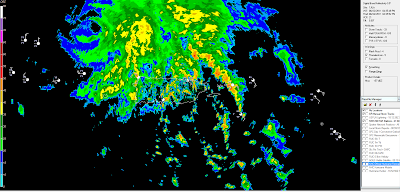
The storm total rainfall estimates from the same radar site (see image below) indicate widespread rains of 2-4 inches with localized amounts near 6 inches across much of Puerto Rico during the last 24 hours:
With Puerto Rico being cleared by the system during the next 12 hours, the primary focus now turns to the future track and intensity forecast of Irene as she blasts through the Bahamas and toward the U.S. Coastline.
The image below shows the latest composite of the various computer forecast model solutions for Irene over the next 5 days:
As you can see, not only has the model consensus shifted Eastward (as we expected), but it has now even shifted to the East of the Hurricane Cleo path from 1964. The average forecast path (according to the models) now more closely resembles that of Hurricane Floyd from 1999:
The NHC is currently forecasting Irene to reach major hurricane strength over the Northern Bahamas on Thursday. With the center of Irene now forecast to pass to the North of the most rugged terrain of the Dominican Republic tonight and Tuesday there will be even more opportunity for the system to remain well organized and intensify even more rapidly.
It is important to keep in mind that when we plot the points of Irene on any forecast map (whether computer models or the human forecaster's interpretation of the models), we are plotting the center point of the system only at any given time. Both hurricane and tropical storm force winds will extend well out from the center of Irene by the time she approaches the U.S., so even if the center of Irene passes East of Florida, as currently expected, the Eastern portions of the state will still be impacted by strong, gusty winds (quite possibly to hurricane force) and high wave action on Thursday and Friday. The extent to which Florida will be impacted will become better known in the next 24-36 hours. In the meantime, residents should continue with preparedness actions until the impact on the region becomes more clear.
There is little doubt that Irene will have become a major hurricane by the time she approaches the U.S. coast. If the expected Northwest turn takes place over the central Bahamas on Thursday, and then the expected curve toward the North/Northeast takes place on Friday, then major hurricane Irene is likely to make landfall somewhere along the Carolina coasts on Saturday. At this time, computer models, climatology and pattern recognition suggest that winds are likely to be in excess of 130 mph when Irene makes landfall (thus the classification of a "major" hurricane).
It also continues to appear likely that Irene's impact will be felt even further Northward, along much of the middle and upper Atlantic seaboard, into the coming weekend. The latest GFS Computer Model forecast valid 8pm EDT on Sunday, 8-28-11 is shown below, which indicates the center of the system along the coast near New York City at that time:
As we've been saying for the past several days, all residents along the Eastern U.S. seaboard, from Florida through New England need to keep a very close eye on the forecast track and intensity of Irene over the coming days.
If you live in (or near) the threat areas described in this post, please take action now by reviewing Hurricane Preparedness Tips, obtaining the necessary supplies and making final evacuation plans so that you're not caught off guard at the last minute.
If you enjoy reading 'The Original Weather Blog', please be sure to "like" our facebook page!


No comments:
Post a Comment