Showing posts with label Hurricane Irene. Show all posts

Friday, August 26, 2011

New York City Airports Closing at 12 Noon Saturday

The Port Authority of New York has announced that all major New York City airports will be closed effective 12 Noon EDT on Saturday due to the approach of Hurricane Irene.


Even if you have a flight scheduled prior to the airport closures, I highly suggest calling ahead to make sure it hasn't been cancelled already.


The closure of the NYC area airports will cause a huge bottleneck in the nationwide air travel system that is likely to last well into next week... regardless of what type of physical damage Irene does to the area.


If you enjoy reading 'The Original Weather Blog', please be sure to "like" our facebook page!

First "Irene" Tornado Watch Issued...


The SPC in Normanhas just issued a Tornado Watch for portions of far eastern North Carolina, including the Outer Banks, valid until 5am EDT Saturday.


Tornadoes often occur in association with tropical systems, due to the warm, buoyant, tropical air and copious amounts of rotation associated with the system.  Tropically-induced tornadoes are usually rather weak and short lived.


If you enjoy reading 'The Original Weather Blog', please be sure to "like" our facebook page!


Hurricane Irene: Warnings Extended Northward; Significant Impacts Likely


Above are the latest visible ("naked eye view"), infrared (measures the cloud temperatures) and water vapor (measures the moisture content) satellite images of Irene.  As you can see, the eye of Irene is beginning to emerge once again on the infrared and especially on the water vapor imagery.


As of the 5pm EDT National Hurricane Center (NHC) Advisory, Hurricane Warnings were extended Northward as far as Sagamore Beach, MA.  This means that a Hurricane Warning is now in effect for New York City, Long Island, Long Island Sound, Coastal Connecticut and Rhode Island, Martha's Vinyard and Nantucket.  See the color coded NHC map below for a visual representation:


Irene is moving toward the North/Northeast at 14 mph, with a minimum central pressure of 28.05 inches of mercury (950 millibars) and maximum sustained winds of 100-105 mph (statistics as of the 8pm EDT NHC Advisory).  


Both the satellite imagery and the latest Charleston, SC radar image (below) show that some of heaviest squalls yet are about to move onshore across the Carolinas:


For more detailed information on the likely impacts across North Carolina, please see my latest Hurricane Irene Impacts post here.


The center of Irene will move out over the Gulf Stream throughout the evening and overnight hours, which I believe will result in gradual intensification (note the recent drop in pressure compared to the observation 3 hours ago).  As mentioned in the North Carolina-specific post referenced above, I expect Irene to have maximum sustained winds of at least 115 mph as she approaches the outer banks tomorrow.  Some computer models forecast even higher sustained winds by that time.  We will have to monitor trends this evening and overnight for additional updates.


Beyond North Carolina (again, for specifics on North Carolina, please go to this recent post), Irene is forecast to have significant impact all the way up the coast through the Baltimore/Washington area and into New York City, Long Island and New England over the weekend.


Based on the latest observations and computer forecast model guidance, here is how I see the primary wind threats panning out this weekend:


Another important thing to remember about the winds with Irene has to do with the duration of the event.  The winds shown on the image above are the maximum expected sustained winds and wind gusts.  Those maximum winds will take place for a period of 6-9 hours at any given location, based on the current expected movement of Irene.  Less intense, but still strong, winds will take place for up to an additional 12 hours at any given location (i.e., tropical storm force winds that arrive well before the hurricane force winds, etc.).  This will result in local areas being impacted with sustained 40+ mph winds and frequent gusts of 60+ mph for 18-24 hours total in some areas!


In addition to strong winds, very heavy, potentially flooding rainfall of 6-10 inches with localized amounts of 12-14 inches can be expected along the path of Irene.  With grounds already saturated from recent rainfall, added to the heavy rains from Irene and the strong winds, this will create the potential for widespread tree damage, which will increase an already high threat of widespread power outages.


Most of the major metropolitan areas, including New York City, have announced that transit systems will be shut down beginning sometime Saturday.  Now is the time to act.  If you live in a flood or storm surge prone area (i.e., Evacuation Zones A and B in the New York City area), I strongly suggest that you consider moving West this evening or early Saturday to avoid Irene.  There will be no public mode of transportation after tomorrow afternoon, and the roads are also likely to become grid-locked in some areas by that time as well...


The City of New York has declared a mandatory evacuation for Zone A.


Beyond the wind, rain and flooding impacts of Irene, storm surge will also be a significant problem in many areas.  Depending on exactly when the center of Irene passes through a given location (in relation to high tide, etc.), significant amounts of water can be expected to be pushed inland, including in the New York city area (hence the cause for the evacuation call for Zone A in New York City - and, frankly, I don't like the chances for Zone B either).


Power outages will be widespread, and communications will also be severely disrupted in many areas.  That's why we strongly encourage you to take action now before the storm gets any closer.


I will post additional region-specific updates as a more precise idea as to the specific impacts emerge.


If you enjoy reading 'The Original Weather Blog', please be sure to "like" our facebook page!

Wrightsville Beach, NC Getting Hammered....


The above LIVE webcam view from Wrightsville Beach, NC (just outside Wilmington) is growing more impressive by the hour. Graphs of the corresponding surface weather conditions in the area show a steady increase in both sustained winds and gusts, as well as a steady decrease in barometric pressure:


As you can see on the above graphs, wind gusts are now approaching 50 mph, with steady winds of near 40 mph at times.  This trend will continue to increase into the evening and overnight hours...


For more details on what can be expected across North Carolina, see my earlier post here.


Somebody put a windshield wiper on that camera!


If you enjoy reading 'The Original Weather Blog', please be sure to "like" our facebook page!


Update on Hurricane Irene Impacts: North Carolina


The above visible satellite image shows Irene continuing to hold good form as she slowly advances toward the Carolinas. At 5pm EDT, the center of Irene was located approximately 265 miles South/Southwest of Cape Hatteras, and moving Northward at 14 mph.  Maximum sustained winds remain between 100 and 105 mph.   I still anticipate at least slight strengthening this evening or tonight as the center of Irene passes through the warm waters of the Gulf Stream.  This up-tick in intensity also continues to be forecast by the computer models as well...


Regardless of whether Irene has sustained winds of 105, 110 or even 115 mph on Saturday, the impacts along the coast and inland across North Carolina and southeast Virginia will be significant.


Tropical storm force winds have already been observed along the South Carolina coast this afternoon, and are spreading Northward up into North Carolina at this time.  A fan of my facebook page, Melissa Ham, was kind enough to give me this link to an awesome live webcam at Wrightsville Beach, North Carolina.  It's being buffeted around by tropical storm force winds and heavy rain right now.  The radar image below from Charleston shows squalls with heavy rain continuing to advance Northward into the regoin around the Northwest side of Irene:


Hurricane force winds will then overspread the region during the overnight hours and into early Saturday morning.


At this time, it appears that the center of Irene will pass directly over the Pamlico and Albemarle Sounds (somewhere between Cape Hatteras and Williamston) by midday on Saturday.  The image below is the GFS computer forecast model, valid 2pm EDT Saturday:


Another computer model, called the HWRF, valid at the same time and zoomed-in tightly on the Carolina coast shows the center heading in the same general direction, but a little bit slower on this model:


While the two models differ slightly on the exact position of the center at 2pm tomorrow, the do agree on the geographical track, and they also both forecast Irene to be stronger at that time than she is now.  The GFS is forecasting a maximum surface wind of 115-120 mph, while the HWRF is forecasting a maximum surface wind of 130 mph.  Both of the models forecast Irene to intensify tonight and tomorrow morning as she moves across the Gulf Stream (as a pointed out a few paragraphs above).


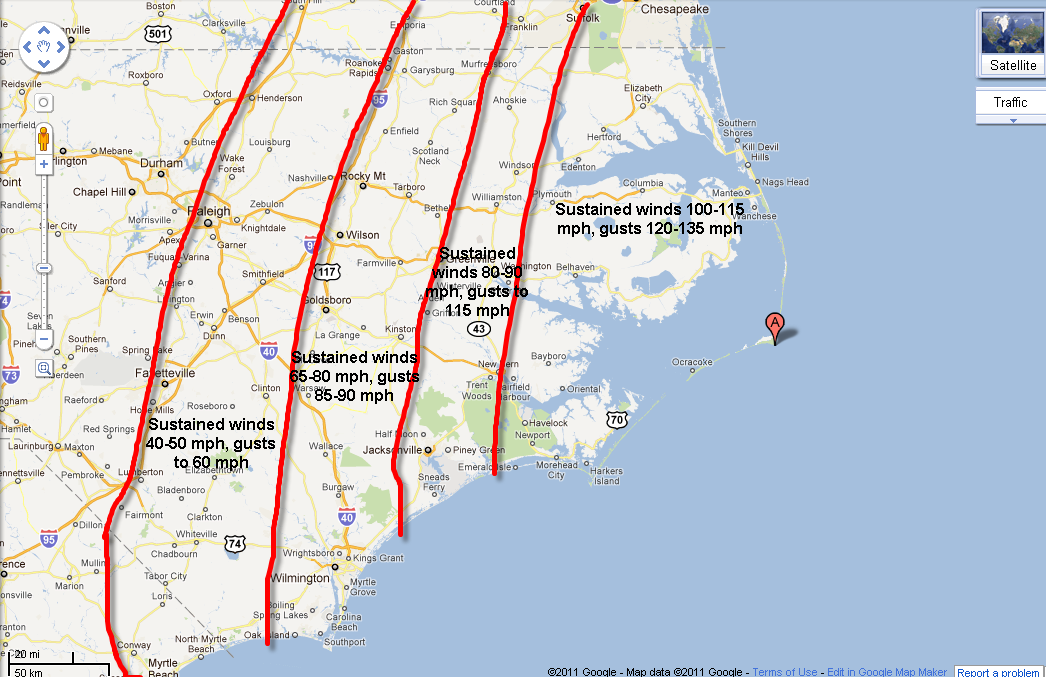
I am in the camp that believes she will undergo at least modest intensification in the Gulf Stream tonight and Saturday morning.  Lets assume that she does intensify but go with the lowest sustained winds estimated by the above 2 models, at 115 mph.  That refers to the maximum sustained wind, which would take place within 30 or so miles of the center, across the Outer Banks, the sounds and adjacent portions of the mainland (mainly East of Highways 13 and 17, to the East of a roughly Murfreesboro to Jacksonville line).


To the West of that line, up to I-95 and I-40, sustained winds of hurricane force, with gusts up to 85 or 90 mph can be expected.  From there on back as far as the Raleigh-Durham and Fayetteville areas, sustained winds of tropical storm force (40-50 mph) with gusts to 60 mph will be a strong possibility.


I apologize for the crudeness of the image above, I just wanted to try and get this information out there as quickly as possible, as folks across this region should be rushing preparedness plans to completion at this time.  As I pointed out way up at the top of the post, winds will increase to tropical storm force across this region this evening and early tonight, then reach hurricane force in the indicated areas by late tonight or early Saturday morning (spreading from South to North).  The maximum sustained ranges and gusts indicated on the image above would likely take place beginning from mid-morning (in the South) to late afternoon (in the North) on Saturday, and based on the expected movement of the system could last from 6-9 hours in any given area.  As you can see, this will not be a short-lived event with respect to very strong, potentially damaging winds.


As I pointed out in my post concerning this region yesterday evening, the grounds are already saturated from recent rains.  An additional 6-12 inches of rain will fall across this region with Irene, about half of which could well take place even before the stronger winds arrive on Saturday.  Trees, many of which are already loaded with moisture, will become even more saturated while sitting within saturated (if not flooded) grounds.  All of these factors will come together when the winds arrive to produce widespread tree damage, which will also increase the threat for widespread power outages across the region.  If you don't already own a generator and think that you can find one at this late hour, it may prove to be a very wise investment...


Storm surge will be another issue with Irene.  The image below is called an "inundation map" and shows the forecast maximum impact of storm surge flooding by Irene:


The red shaded areas suggest 9-11 feet of water in those areas, while the orange and yellow shaded areas suggest 5-9 feet of water can be expected due to storm surge.  The image below is a close-up view of the area that is currently forecast to have the greatest surge impacts:


Heavy rainfall will also induce flash flooding in many areas, with 10-14 inches of rain currently forecast for the Eastern half of this area tonight through Saturday night.  


For additional information on specific local evacuation orders and expected storm surge magnitudes, please go to this link and select the office nearest you.


Hopefully folks across this area have heeded the warnings this week and are well prepared (if not heading West) to handle Irene.  


I'll have a full East Coast-wide update on Irene in a short while, along with updates for the Baltimore/Washington, New York City/New Jersey and New England areas later this evening...


If you enjoy reading 'The Original Weather Blog', please be sure to "like" our facebook page!

Midday Irene Update; East Coast Should Continue Preparing for Major Impacts


The latest visible (above) and infrared (below) satellite images still show a very symmetrical Hurricane Irene tightly wound up as she slowly approaches the Carolina coastline...


The eye is not currently visible, and the latest Hurricane Hunter aircraft mission "only" found a maximum sustained wind of 105 mph at the surface (much stronger winds of up to 130 mph were located right off of the surface).  We still can't really tell at this point whether the present eye and surface wind conditions have to do with an eye wall replacement cycle (see my post earlier today) or not.  If they do, then the eye will emerge again later today, and the winds are likely to grow stronger once again.


I am not ready to say, as some within the government and media are, that Irene has finished intensifying.  She still has 18+ hours before the 1st landfall, during which time the center will reside over the very warm, buoyant waters of the Gulf Stream for several hours.


As you can see by the latest image from the Charleston, SC radar, the eye of Irene is becoming visible a couple of hundred miles offshore (as noted by the red arrow):


The rest of the particulars from the 11am EDT National Hurricane Center (NHC) Advisory:  The center of Irene was located about 330 miles South/Southwest of Cape Hatteras, NC.  The minimum central pressure was 27.93 inches of mercury (946 millibars), and the movement was North at 14 mph.


Watches, warnings and advisories largely remain unchanged from the early morning NHC update, and can be seen on the image below:


I would expect the Hurricane Watches to be upgraded to Warnings by the late afternoon package.  Regardless of whether they "officially" are or not, I strongly encourage residents across that part of the region to continue rushing preparedness plans to completion today.  Major disruptions in transportation and potentially communication will make it more difficult to get to safety over the weekend.


Irene is a large, powerful storm.  Tropical storm force winds currently extend nearly 300 miles from the center, and hurricane force winds extend out nearly 100 miles from the center.  The potential for widespread wind damage, power outages, communications outages, storm surge and rainwater flooding continues to be very high in association with Irene all along the East Coast from North Carolina up into New England.


For specific local information on evacuation orders, please go to this link and select the National Weather Service office nearest you.


I will be closely monitoring observational and the latest midday computer model runs and plan a full, updated post on my thoughts on the future impacts and track of Irene late this afternoon or early this evening.  We should know with greater certainty by that time whether what we're witnessing right now is simply a fluctuation in intensity or something more permanent.  Either way, Irene will continue to be a significant hurricane with significant impacts on the way all along the East coast, as outlined in my region specific posts yesterday evening (those posts will be updated this evening as well).


If you enjoy reading 'The Original Weather Blog', please be sure to "like" our facebook page!

"Signal Strength" - Cellphone Networks Expected to 'Crash' in Irene...


Interesting article on CNET News regarding the "hit" that the cellular phone network is expected to take (literally and figuratively) from Hurricane Irene.


It sounds like the major cellular network carriers are placing emergency generators and extra fuel near transmission sites, etc., in an effort to combat the likely power outages.  This is fine, assuming that the towers and/or equipment remain functional during powerful winds, storm surge flooding, etc.


They echoed a suggestion that I made a couple of days ago in that you should plan to send short text messages or e-mails to communicate with family rather than trying to make voice calls which require greater network resources...


I think a reminder should also go out to please conserve voice phone calls during the height of the storm to true emergencies only.  That way those who do need to make an emergency call have a better chance of getting through.


If you still haven't purchased an emergency back-up power supply for your cellphone or smartphone, it's not too late to do so.  Head over to RadioShack today and they'll get you fixed up!


If you enjoy reading 'The Original Weather Blog', please be sure to "like" our facebook page!

Radar Lighting Up Ahead of Irene...


The above image was just taken from the Jacksonville, FL radar site. You can see spiral bands around the Northwestern side of Iene advancing toward the northern Florida and Carolina coasts.  You can also see the outer bands surrounding the eye off toward the center-right portion of the image.


Another view of Irene from the Wilmington, NC radar is shown below:


You can see a much larger swath of precipitation associated with the Northwestern quadrant of Irene advancing toward the Carolina coasts.  


Conditions will deteriorate across this region throughout the day today as additional squalls and areas of rain and thunderstorm activity, some heavy, overspread the region.  This will hamper preparedness efforts in some areas, which is why we were encouraging that activity to be completed ASAP for the last few days...


In addition to the increasing threat of heavy rain, isolated tornadoes often form within the thunderstorm squalls of hurricanes.  The greatest risk of tornadoes is typically from activity within the Northeast quadrant of the storm (which is currently out over water), however isolated tornadoes cannot be ruled out with stronger storms that move inland across the Carolinas today.


For additional information on mandatory and voluntary evacuation orders that are in place across the region, please go to this link and select the local office that serves your area.


If you enjoy reading 'The Original Weather Blog', please be sure to "like" our facebook page!


Don't Be Fooled by "Irene Weaker" Claims - Please Continue Preparing for a Major Hurricane


Above is the latest infrared (cloud temperature) satellite image of Irene, and below is the 1st visible ("naked eye" view) image of the day as the sun rises over the East.


As you can see, Irene is still a very tightly wound, well organized hurricane.  It appears that she may be going through another eye wall replacement cycle, as you can see vigorous thunderstorm development (higher, more bubbly cloud tops) right around the eye, particularly on the visible image.  The same thing took place night before last, and is common in strong hurricanes.


Eye wall replacement cycles are nearly impossible to predict.  No one really knows why they choose the times that they choose to take place.  The are usually short lived.  If recent trends hold, we will probably see the eye emerge clearly again on satellite imagery later today.


I nearly fell out of my chair this morning when I read the 5am EDT discussion and advisory from the National Hurricane Center (NHC).  The headline on the Public Advisory read:  "Irene Slightly Weaker..."  I cannot think of a more irresponsible thing to say when we have a hurricane of this magnitude likely to intensify further before impacting a corridor of 50+ million people - not to mention in a region that is not use to this type of intense storm.


Thankfully, the follow-up advisory at 8am EDT changed the headline to "Irene Taking Aim at the East Coast..."  Thank you for coming back down to earth.  Some changes were also made to the watches and warnings with the morning set of advisories.  The hurricane watch along the Jersey coast to New York City has been changed to a Hurricane Warning (bright red shaded area on the image below).  A Hurricane Watch (pink shaded area on the same image) has also been issued Northward to Cape Cod and Nantucket:


I disagree with the decrease in maximum sustained wind speed from 115 to 110 mph on the 5am (and maintained on the 8am) advisory.  The pressure inside the center of Irene (which closely correlates to the strength of the wind field) argues that she has maintained intensity overnight, not lost intensity.  An Air Force Hurricane Hunter aircraft detected a minimum central pressure of 942 millibars (27.82 inches of mercury) just before 5am EDT.  This is the same pressure that was in place on the observation late yesterday evening.


Now granted, a 5 mph difference in neither here nor there when it comes to a hurricane of this size and strength, and some fluctuations in intensity are likely if an eye wall replacement cycle is indeed underway.  The point I'm trying to get across is that in my opinion it is irresponsible and sends a terrible message to the public at large when you say things like "weakening, weaker..." or even "slightly weaker" given the other considerations that I outlined a couple of paragraphs above.


I'm sure emergency managers are also frustrated by this mixed signal that is being sent out to the public, and will likely be magnified by the "main stream media" throughout the day today.  Hopefully folks won't be fooled and will press on.  There is absolutely no change or new information in observational data (radar, satellite imagery, surface observations, aircraft observations) or computer model data (and an unprecedented amount of data has been flowing into the models all week long) that suggests any significant change in the strength or track of Irene since the information provided yesterday evening.


For specific details on my thoughts as to the future path and impacts of Irene, please see my full detailed post here.  Please also refer to region-specific posts that I made yesterday evening pertaining to potential impacts on:  North Carolina, Baltimore/Washington and New Jersey, New York City and Long Island.  I will update each of these posts during the day today, but for now the message is unchanged:  Please continue preparing for dangerous hurricane Irene if you live in these areas!


Please go to this post for more information on preparing for an approaching Hurricane.  Please refer to this post for information on creating your own severe weather and hurricane survival kit.


If you enjoy reading 'The Original Weather Blog', please be sure to "like" our facebook page!


Thursday, August 25, 2011

Pressure Falling Inside Irene; Winds to Increase Soon...


According to recent Hurricane Hunter Aircraft observations, the barometric pressure is falling and the eye wall is contracting inside Hurricane Irene, both signs that the expected increase in surface winds will follow shortly...  


At 11pm EDT, the center of Irene was located 490 miles South/Southwest of Cape Hatteras, North Carolina. Maximum sustained winds were 115 mph, and the minimum central pressure was 27.82 inches of mercury (942 millibars).


Irene continues to make a turn more toward the North (as expected) this evening, and is now moving just slightly West of due North, at 14 mph.


Irene continues to move into a very favorable environment for intensification, and is highly likely that she will intensify further tonight and/or Friday.


The forecast track has not changed from my detailed post earlier this evening.  Please also refer to region-specific posts that have been made throughout the evening pertaining to potential impacts on:  North Carolina, Baltimore/Washington and New Jersey, New York City and Long Island.


Please go to this post for more information on preparing for an approaching Hurricane.  Please refer to this post for information on creating your own severe weather and hurricane survival kit.


If you enjoy reading 'The Original Weather Blog', please be sure to "like" our facebook page!

New Jersey, New York City, Long Island to See Major Impacts from Irene

I know that "official" hurricane warnings are not in effect for the region at this time, but I want to emphasize that Hurricane Irene is a very large, dangerous storm.  If the various computer model scenarios that are playing out come to pass, a very significant threat will exist across New Jersey, New York City and Long Island, with respect to both wind damage and storm surge, late Saturday night and into Sunday.


I won't be quite as specific in this post as I have been in a few others this evening, mainly because I want to evaluate additional data tonight and Friday.  With that said, the scenario shown on the GFS computer model image below, valid 8am EDT on Sunday morning, would result in a large amount of water being pushed up Long Island Sound and New York Harbor, into the East River:


...and that would only be the beginning.  This image, valid at 11am EDT Sunday depicts 70-80 mph sustained surface winds in New York City (keep in mind that winds at the upper stories of skyscrapers would be even higher), as well as most of New Jersey and Long Island.


I don't see how the City of New York will be able to avoid calling for the complete evacuation of both zones A and B (orange and yellow shaded areas on image below - click link above for PDF version of map) if this scenario plays out as currently expected.  In fact, if you live in evacuation zone A or B, I wouldn't even wait for the City to tell you - I'd plan to be out of that area by Saturday afternoon.  Make arrangements to stay with a friend or relative further inland.


This also brings up another point, with the potential for rain and/or storm surge induced flooding, as well as widespread wind damage across New York City late Saturday and into Sunday, I would expect major disruption - if not a total shutdown - of mass transit systems.


This is a very dangerous and potentially life threatening situation.  If you live across this region, please heed all warnings and local evacuation orders.  Your preparation and evacuation plans should be well underway at this time, and you should strive to complete those actions by the end of the day tomorrow.


Tomorrow we'll be able to become even more specific with respect to the potential threats that Irene will pose to the region.


For more details on the expected track and East Coast impacts of Irene, please see my earlier post here.  Check back frequently on Friday for updates.


If you enjoy reading 'The Original Weather Blog', please be sure to "like" our facebook page!

Hurricane Irene Impacts: Baltimore/Washington Area

I won't be as specific in this post as I was in my last impact post (which dealt with the threat to North Carolina). Not because the potential impacts are any less for the Baltimore/Washington area (which is certainly not the case) but because we still have some time to monitor Irene's progress and fine tune the intensity and track forecasts on Friday.


With that said, I feel strongly that the Baltimore/Washington area will face significant impacts from Irene on Saturday evening and into early Sunday.


Let's start with the GFS computer model forecast, valid 5pm Saturday:


The affects will already be felt by this time.  If the above model verifies, and it has a very good chance of doing so, large swells will be pushed up into the Chesepeake Bay, potentially flooding portions of Baltimore.


In addition to the threat of storm surge flooding, strong, damaging winds are also likely.  By the 8pm EDT Saturday evening to 2am EDT Sunday morning timeframe, the GFS model depictions below are forecasting sustained winds of hurricane force as far West as Baltimore and Washington:


As I pointed out in the North Carolina impacts post earlier, vegetation and trees are loaded with water across this region from higher than normal rainfall this spring and summer.  This, in addition to widespread 6-8 inch rains that are forecast with Irene (see image below), along with strong winds will further enhance the potential for widespread tree and power line damage, which will further increase an already very high threat of widespread power outages across the region.


This is a very dangerous and potentially life threatening situation.  If you live across this region, please heed all warnings and local evacuation orders.  Your preparation and evacuation plans should be well underway at this time, and you should strive to complete those actions by tomorrow.


Tomorrow we'll be able to become even more specific with respect to the potential threats that Irene will pose to the region.


For more details on the expected track and East Coast impacts of Irene, please see my earlier post here.  Also, watch for upcoming detailed posts for specific areas further North along the forecast path, which are forthcoming later this evening and/or tomorrow....


If you enjoy reading 'The Original Weather Blog', please be sure to "like" our facebook page!

Severe Weather / Hurricane Safety Kit Refresher...


If you live in the path of Hurricane Irene, part of your preparedness plan should include having a severe weather and hurricane survival kit on hand.  Please go to this post for more details...


If you enjoy reading 'The Original Weather Blog', please be sure to "like" our facebook page!

Hurricane Irene Impacts: North Carolina

As we've been warning for days now, the first major impact that Irene will have on the U.S. East Coast will take place across North Carolina on Saturday.  The sequence of images below shows the Global Forecast System (GFS) computer model forecast valid at the times indicated below each image.  


When examining the images, keep in mind that the colors surrounding the center of Irene represent the following surface wind speeds:  brown, 100-115 mph; dark red, 90-100 mph; lighter red, 80-90 mph; orange, 70-80 mph; yellow, 60-70 mph: 


Valid 2am EDT Saturday


Valid 8am EDT Saturday


Valid 2pm EDT Saturday


Valid 8pm EDT Saturday


Valid 2am EDT Sunday


If the above forecast model verifies (and based on the current trends of Irene, this appears quite likely), then widespread, damaging winds of 70-80 mph can be expected as far West as the Raleigh-Durham and Fayetteville areas by mid-morning Saturday.  Just East of this area, on up to I-95 and I-40, winds of 80-90 mph are likely.  To the East of I-95 and I-40, sustained winds in excess of 100 mph are likely.


Rainfall has been generous across this region during the spring and summer months.  The ground is moist, and trees are loaded with moisture.  This will make it even easier for them to be toppled in the strong winds, which will further aggravate an already extreme potential for power outages across the region.


Speaking of rainfall, the latest HPC forecast image below is calling for widespread rainfall of up to a foot along the far Eastern coast of North Carolina, tapering back to the West to the 3-5 inch range in the Raleigh-Durham and Fayetteville areas:


The additional heavy rains, some of which will flow into the region ahead of the stronger winds, will further increase the likelihood of widespread tree and power line damage.


This is a very dangerous and potentially life threatening situation.  If you live across this region, please heed all warnings and local evacuation orders.  Your preparation and evacuation plans should be complete at this time.  Particularly if you live East of I-95, don't chance it and try to ride out the storm.  Such a decision could end up costing you your life.


For more details on the expected track and East Coast impacts of Irene, please see my earlier post here.  Also, watch for upcoming detailed posts for specific areas further North along the forecast path, which are forthcoming later this evening and/or tomorrow....


If you enjoy reading 'The Original Weather Blog', please be sure to "like" our facebook page!

My Ping in TotalPing.com