Showing posts with label Tropical Weather 2011. Show all posts

Friday, August 5, 2011

Will Emily Be Called Emily Again? Tropical Storm Naming Trivia...


The remnants of Tropical Storm Emily are beginning to move into the southern Bahamas this morning (yellow circled area on satellite image above), after taking a battering from Cuba and Hispaniola yesterday.


I've received several e-mails in the last 24 hours all basically asking the same question: If the remnants of Emily regenerate into a Tropical Depression, Storm or Hurricane, what will it be called?  Will the whole thing start over, or will it retain the name "Emily".


That's an excellent question.  Right now, if the system that we see on the satellite image at the top of this post (which is literally the remnants of the original Emily) were to reform into a Tropical Depression, Storm, or Hurricane, it would indeed be called "Emily" again.  That's largely because we can still visibly see the remnants of the former Emily on satellite and/or surface observations.  If the system were to completely diminish and leave no trace evidence on satellite or surface observations, then the classification/naming process we would start over (as there is no longer a "remnant" to trace).


So, with that addressed, the next logical question is what's going on with the remnants of Emily, and will they reform into Emily again?  I think the short answer is yes, we will see Emily again, possibly as early as tomorrow.  The system is moving into an area favorable for development, with respect to both warm waters and a very favorable middle and upper-level wind pattern.  It's for these reasons that the National Hurricane Center (NHC) is currently giving Emily a "high" chance of redeveloping over the weekend.  


Regardless of how this exactly pans out over the next couple of days... heavy showers, thunderstorms and gusty winds will continue to overspread the Bahamas today and Saturday.


If you enjoy reading 'The Original Weather Blog', please be sure to "like" our facebook page!

Thursday, July 14, 2011

Tropics Remain Inactive - Not Unusual for July...

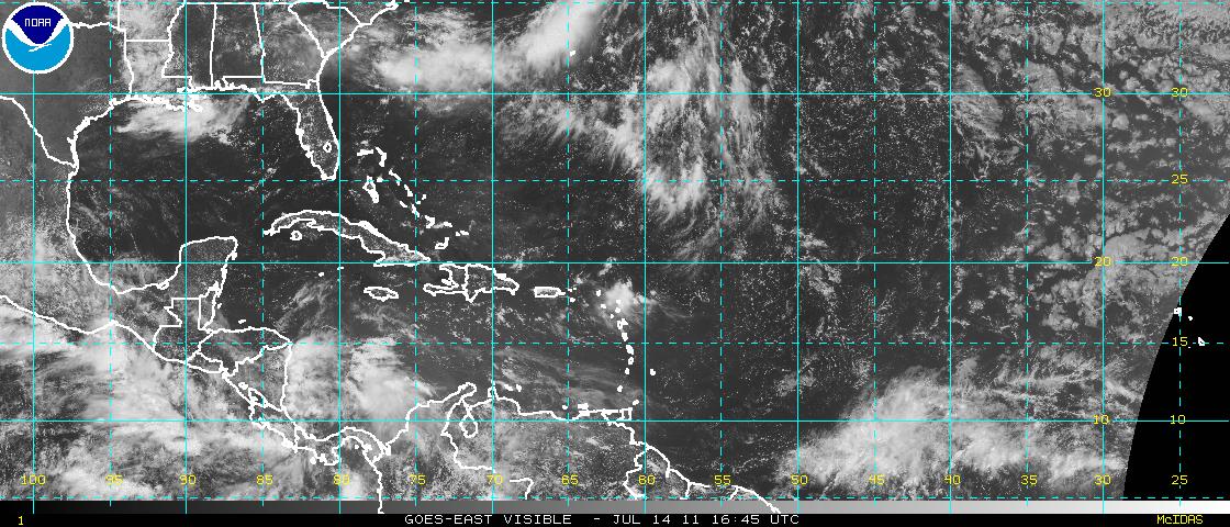
Satellite image of the Atlantic Basin at 11:45 AM CDT 7-14-11


I've received several e-mails over the last week to 10 days from folks along the Gulf Coast that are nervous because the tropics have been so quiet this month.  They seem to be afraid (perhaps at some local media suggestion) that the end of the world is coming in August or September because July has been so quiet.


While it's true that the Tropical Atlantic has been rather inactive for the first half of July - a look at the record books indicates that this is actually "normal".  In fact, during the 159 year period from 1851 to 2010, only 106 named storms (Tropical Storms or Hurricanes) formed in the Atlantic basin.  That works out to less than 0.7 systems per year on average in July.  Of course, some years are more or less active than others, but on average it is not uncommon to see zero or only one named system during the month of July in the Atlantic.


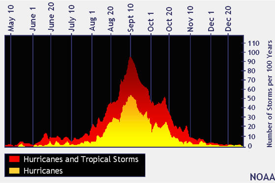
With the above in mind, there is no need to panic that "doomsday" is on the horizon because July has been calm thus far.  At the same time, however, don't let your guard down as we have yet to enter the traditionally "most active" period of the season.  As you can see on the chart below (provided by the NOAA/NHC), Tropical Storm and Hurricane activity typically starts to trend upward during the first part of August, with a peak in early to mid September:


Hopefully if you live along the Gulf or Atlantic coasts you've already prepared for the upcoming season.  If not, now would be an excellent time to review Tropical Weather Safety and Preparedness Tips and make sure that you're all ready to go in the event that a system does threaten your area later this season.


One of the safety and preparedness tips in the above linked brochure suggests that you have a battery powered NOAA Weather Radio available as a source of information on an approaching tropical system.  As always, I highly recommend visiting RadioShack either at your local store or online to view a full line of NOAA Weather Radios that can help you protect yourself and your family during a host of severe weather situations.  The staff there will even help you program your radio if you need assistance!


As I often point out on the blog... it's always better to be prepared in advance and react to a threat in a calm, orderly fashion than to be caught off guard and find yourself in "panic mode" later on...


If you enjoy reading 'The Original Weather Blog', please be sure to "like" our facebook page!
Tuesday, June 7, 2011

2011 Tropical Storm & Hurricane Names


With the tropical season now officially underway, I thought I'd share the list of names that the meteorological community has decided to give to Tropical Storms & Hurricanes this year.


In case you need a refresher course, here is how things typically progress in the tropics, as far as the formation/classification of a system are concerned:


(1). Tropical Wave - developing area of low pressure where thunderstorms are still relatively disorganized.  No real center or sustained wind field.  A name or number is not formally assigned to this type of system, however it may eventually be given an "Invest" (or area of investigation) number as it develops further.


(2). Tropical Depression - developing area of low pressure with more organized thunderstorm activity.  Develops an area with sustained winds of 38 mph or less.  A number is assigned to the system once it reaches this stage (i.e., Tropical Depression One, Two, Three, etc.)


(3). Tropical Storm - organized area of low pressure & thunderstorm activity with sustained winds of 39-73 mph.  A formal name is given to the system at this stage.


(4). Hurricane - organized area of low pressure & thunderstorm activity with sustained winds greater than 73 mph.  Continues with the same name assigned once it reached Tropical Storm strength.


Once a storm reaches Hurricane strength, it is also assigned an intensity on the "Saffir-Simpson Scale" (similar to the EF-scale used for tornadoes).  For more on the Saffir-Simpson Scale, see this post.


Tracking charts are also available below each list of names, click on the image to go to the NHC website for downloadable and/or printable versions...


Below is the list of official names that will be given to Tropical Storms and/or Hurricanes that form in the Atlantic this season:


Arlene

Bret

Cindy

Don

Emily*

Franklin

Gert

Harvey

Irene

Jose

Katia

Lee

Maria

Nate

Ophelia

Philippe

Rina

Sean

Tammy

Vince

Whitney


Below is the list of official names that will be given to Tropical Storms and/or Hurricanes that form in the Eastern North Pacific this season:


Adrian

Beatriz

Calvin

Dora

Eugene

Fernanda

Greg

Hilary

Irwin

Jova

Kenneth

Lidia

Max

Norma

Otis

Pilar

Ramon

Selma

Todd

Veronica

Wiley

Xina

York

Zelda


*We're particularly anxious for the formation of Hurricane Emily around our house this year, as we feel that her destructive power is likely to closely resemble that of our 4 year old daughter of the same name.  For the sake of all those involved, we hope that particular storm remains out to sea....


If you enjoy reading 'The Original Weather Blog', please be sure to "like" our facebook page!
My Ping in TotalPing.com