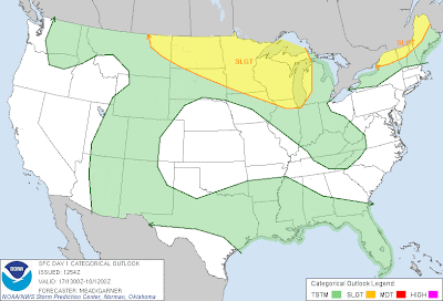
Severe thunderstorms are forecast within the yellow shaded areas on the above image today. Activity is already getting underway at late morning in North Dakota, as shown by the radar image below:
A Severe Thunderstorm Watch is in effect for this region until 5pm CDT:
It appears that the activity currently developing over North Dakota is likely to organize into a cluster or complex of severe storms and move East/Southeastward throughout the day and into this evening. Damaging winds and large hail are the primary threats with this activity, especially within the red and black hatched area on the image below:
Isolated tornadoes also cannot be ruled out, particularly with any storm that is able to remain relatively isolated and become well organized in the first few hours of development.
Additional development may take place out ahead of the organizing complex of storms along a stationary frontal boundary as the atmosphere heats up later this afternoon into this evening. Residents living anywhere within the yellow shaded area from the first image, and particularly those in the red shaded area on the 4th image should remain alert today. Review severe weather preparedness tips and be prepared to seek shelter if threatening weather is observed or a warning issued.
If you enjoy reading 'The Original Weather Blog', please be sure to "like" our facebook page!


No comments:
Post a Comment